Friday, November 28, 2008

Thoughts - EVS Islands and Wikipedia

How To Get Back To Page One On Google Search Results

One gets spoiled having your posts consistently showing up on page one of Google search results. Having recently (11/01/2008) undergone the shame of having my posts moved from page one to page fifty-one, I have pondered how best to get back to page one. I think I have a way - Wikipedia, both praised and reviled, but consistently it's articles are page one on most Google search results.


Wikipedia Page - Old Style

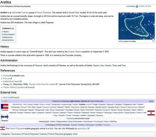
Aratika Atoll Wikipedia Page (Old Style)

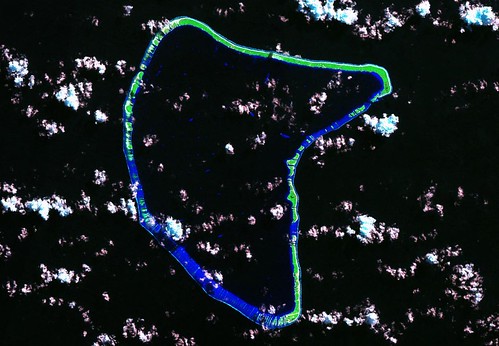
Enter Aratika Atoll and Google returns the Wikipedia entry at page one number two. Go to the entry and previous to my rework of the Wikipedia article, you would have seen the above. An Astronaut Photograph of the atoll, a brief text entry, along with a few Reference links make up the entire article. Frankly, it's okay. However, I decided these atoll / island entries needed a few changes.


Wikipedia Page - New Style (Full)

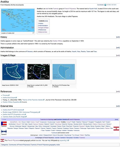
Aratika Atoll Wikipedia Page (New Style)

This is the same article with my changes that not only benefit the reader by adding consistent image content, but also applies some formatting to aid in the flow of information. Let's see what I've done.


Wikipedia Page - New Style (Top)

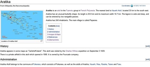
Aratika Atoll Wikipedia Page (New Style - Top)

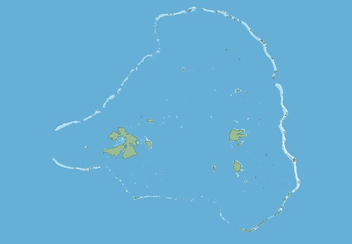
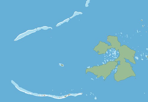
Up top I've included a Tuamotus Locator Map (see the red arrow). It will allow the reader a view of the island within a broader spatial context. I've not added anything to the text portion.


Wikipedia Page - New Style  (Bottom)

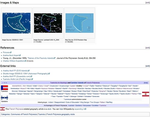
Aratika Atoll Wikipedia Page (New Style - Bottom)

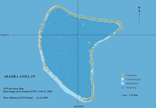
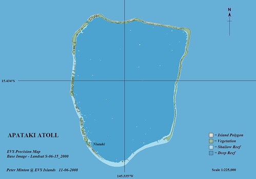
I've added a section called Images & Maps. It is in this section that I post any Wikipedia qualified image or map of the entire atoll. For sure I include the EVS precision map and Landsat image and when available, the ISS (Astronaut Photograph) of the atoll. The External Links section now lists links to the appropriate posts/image/article in EVS Islands, Astronaut Photography and Oceandots.com. Any other links of value would be added, but the first three will always be included.

In my opinion, these changes gives the article a more respectable look and the additional image/map content provides the reader with important spatial information. So far I've modified Wikipedia articles for Aratika, Apataki, Arutua and Tikehau Atolls. I believe what I've done is good for Wikipedia and good for EVS Islands. You know - Win / Win! What do you think?

Sunday, November 23, 2008

Aratika Atoll - A Butterfly Shaped Island Jewel

Aratika Atoll - Landsat S-06-15_2000 (1-115,000)

Aratika Atoll - Landsat S-06-15_2000 (1:115,000)


Aratika Atoll - EVS Precision Map (1-115,000)

Aratika Atoll - EVS Precision Map (1:115,000)

Aratika Atoll, at first glance looks to be a pretty place with little of significance save balmy breezes and lazy days. There are about 240 inhabitants living on the atoll with the majority living in the village of Paparara. The island is not a usual tourist destination. Now for some interesting facts.

One of the founders of modern physical oceanography, Charles Wilkes, visited Aratika Atoll on Sept 3, 1839. Wilkes was given command of the United States Exploring Expedition that was to explore the southern oceans. For the next 3-years his team circumnavigated the globe gathering legions of information. Due to some unfortunate actions on Wilkes part, he was court-martialled for cruelty to members of his crew. He was acquitted of most charges. His later years were spent organizing and writing the results of this expedition.

One other interesting fact associated with this island has to do with two children using their inheritence to invest in a pearl farm on the atoll. A brother and sister made the investment and in 1997 the sister, Dora Fourcade took over the entire pearling operations. Today her company is a success. She is one of only a handful of women in this male-dominated industry.

So what started as just another Tuamotu atoll proved to be rather interesting after all.

Enjoy!

Saturday, November 22, 2008

Thoughts - Mapping Truk Atoll and Still Frustrated and Angry With Google

Truk Atoll - EVS Precision Map  (1-350,000)

Truk Atoll - EVS Precision map (1:350,000)


Truk Atoll - EVS Precision Map  (1-100,000)

Truk Atoll - EVS Precision Masp (1:100,00)

Yes! I'm still making maps. This latest unfinished project resulted from a conversation with the Chief Machinist on a ship that travels periodically to Truk Atoll, now known as Chuuk Atoll. It was the site of a devastating air raid, Operation Hailstorm, that sunk 70 Japanese ships. Aircraft and ground fortification were also targeted. The attack was a total success and viewed by some as America's revenge for Pearl Harbor. Today, divers from around the world travel to this lagoon of ghost ships to explore the relics of war. The young man said charts of the lagoon were of poor quality. I promised him a high quality map (not nautical chart) of the atoll. In addition, I intend to plot sunken ship locations.

GOOGLE, YOU REALLY MESSED WITH MY VISIBILITY

I finally figured out why I am so frustrated first and angry second with the folks at Google. On November 1st someone at Google made a change that negatively affected my post's page rankings. Let me share what I've discovered about the ranking of just one of my past mapping efforts, Anaa Atoll, which previous to Nov 1st, was on Google's page 1 search results.

Anaa Atoll shows up in the number 8 position on page 1 of Yahoo! search results and in the number 3 position on page 1 of MS Live Search results. Yet, it shows up in the number 10 position on page 12 of Google's search results. I am sorry, but that's messed up! The 120 sites pushed ahead of mine are largely of little value (weather, airfares, hotels, etc.) to a person wanting to learn something of substance about this atoll.

I don't want to sound pompous, but my map work is of a high quality and I share it with any and all. I work hard at perfecting my mapping craft and ensure my Google website maintains the highest quality. And now, someone at Google made a change that negatively affected the ranking of information from my site. As a result, my European and Asian readership is down to 4 or 5 pageviews a day and was previously 30 to 50 pageviews a day. My USA readership is down to 10 to 20 pageviews per day and was previously 100 plus pageviews per day and growing. All of this because a Google techie made a change that has wreaked havoc on my website's visibility.

I've checked my "robots.txt" file and it seems to be in order, but even if it wasn't I couldn't change it. Google controls that. I've emailed twice to the black hole called Google Webmaster and was assured someone would read my email, but would not contact me with their solution. Google is so good on so many levels, but truely sucks when it comes to resolving an issue such as mine. They allow you to email, but do not answer. They never give you a name, a phone number...

Argh! I'm just really frustrated. I've worked very hard for the past 3-years building the quality of my website. Things were great. My hard work and the quality mapping projects produced were paying off with increasing pageviews. Now, because somebody at Google made a change affecting my website on Nov 1st, my 3-years of hard work have been virtually erased. I am back to square one, trying to figure out a Google-less way to share my island mapping projects. But, if Google isn't in the picture, neither is your work. Damnit!@

Tuesday, November 11, 2008

Apataki Atoll FP - Another One Bites The Dust

Apataki Atoll FP - Landsat ETM+ S-06-15_2000 (1-225,000)

Apataki Atoll FP - Landsat ETM+ S-06-15_2000 (1:225,000)

There are ten islands within the Palliser Islands. With the completion of Apataki Atoll, I have mapped nine of the ten. Still to do is Rangiroa Atoll, the largest in the Tuamotus and one of the largest in the world. It will have to wait for another day.

Apataki Atoll is 27-km wide by 36-km long and approximately 105-km in circumference. It has a population of 430, with the majority living in the village of Niutahi. The lagoon has at least two entrances permitting larger sailing vessels passage into and out of the lagoon. There is an airfield located adjacent to the village. The island does have accomodations for visitors.

With all that said, lets get to the real joy - the EVS precision map of the atoll!


Apataki Atoll FP - EVS Precision Map from Landsat S-06-15_2000 and DigitalGlobe (1-225,000)

Apataki Atoll FP - EVS Precision Map from Landsat S-06-15_2000 and DigitalGlobe (1:225,000)

Using two base image sources, Landsat ETM+ and DigitalGlobe, this project took approximately six hours to complete. The map consists of 192 island polygons. If Landsat shows a vegetation color signature, I map it as a portion of the vegetation layer. The other two layers consist of a shallow reef and a deep reef. Once the EVS precision mapping was completed, I finished my work using ImageForge, which allows me to add lat/lon, legend, north arrow and credits.


Apataki Atoll FP -Niutahi Village - Landsat ETM+ S-06-15_2000 (1-7,500)

Apataki Atoll FP -Niutahi Village - Landsat ETM+ S-06-15_2000 (1:7,500)

This is an extreme closeup of Niutahi village. I do have an EVS precision map of this portion of the atoll, but I decided to work with a DigitalGlobe overlay to provide additional details to the village area.


Apataki Atoll FP - Niutahi Village - Georectifying DigitalGlobe Image using Global Mapper

Apataki Atoll FP - Niutahi Village - Georectifying DigitalGlobe Image using Global Mapper

Finding the atoll in Google Earth and determining that DigitalGlobe imagery exists for the atoll, I zoomed in and saved an image of the village proper. In order to georectify the image to create an overlay that would align with my Landsat base image, I had to import the DigitalGlobe image into my mapping software, Global Mapper. Using GM's georectifying tool, I determined that the triangulation method using seven GCPs would create the best alignment.


Apataki Atoll FP -Niutahi Village - Georectified DigitalGlobe Image from Google Earth (1-7,500)

Apataki Atoll FP -Niutahi Village - Georectified DigitalGlobe Image from Google Earth (1:7,500)

Once georectified, the DigitalGlobe image aligned quite well over my base Landsat image. Using the triangulation georectifying method, which requires a minimum of 5+ GCPs, allowed for image distortion, which was necessary. This method allowed the DigitalGlobe image to be stretched and tugged into place.


Apataki Atoll FP -Niutahi Village - EVS Precision Map from DigitalGlobe Image from Google Earth (1-7,500)

Apataki Atoll FP -Niutahi Village - EVS Precision Map from DigitalGlobe Image from Google Earth (1:7,500)

I was able to map Niutahi village at 1:7,500 scale. I could have pushed to a finer scale, but for my purposes, this scale worked just fine. I did add a road layer (orange lines) and an airfield layer (grey polygon).

In the center of the lagoon the Landsat image has cloud issues. I was not able to map any of the central lagoon coral heads which I identify as shallow reef, otherwise this EVS precision island map is done.

Enjoy!