Friday, July 27, 2007

Thoughts - GoDaddy URL and Still On Vacation

I'm still on vacation, but my daughter-in-law lets me use her computer. So while my wife reads or naps, I compute.

During one of my computing session, my son suggested I secure the URL www.evs-islands.com. I found that it was available and for a mere $7.15 per year, it's mine. I used GoDaddy.com to register my URL. It was a fairly simple process lasting about 20-minutes.

Once I owned www.eve-islands.com, I checked it out and, sure enough, it was live. Nothing was in it, but it was alive.

Using a Setting feature within Blogger that lets me use my own URL while displaying my blog site's data within it,I decided to go for it. I made a few changes to my blog's settings and in my GoDaddy account and...LINK!

Actually, the link took about 2-hours to establish. Now, when you visit my blog site, evs-islands.blogspot.com, Blogger redirects you to my new URL, www.evs-islands.com.

I'm not sure how Google searches will work with this new link. Whether Google will place my post's URL's into my Blogger blogspot URL or into evs-islands.com URL?

You might ask, "Why spend time explaining this URL stuff on an island mapping site?" I know that many of you enjoy my island maps and posts discussing the How's and What For's, of mapping. However, I suspect many of you would love to establish your own content on the WWW/Internet. This URL business is an important step toward establishing your content's credibility on the WWW/Internet. I enjoy the flexibility and ease-of-use Blogger provides. Yet, the addition of the word blogspot within your URL somehow brings the validity of your content into question. Most readers could care less about this blogspot business, but, after 2-years of blogging, I am here to tell you blogspot within your URL is not a plus. Using Blogger's blogging features, you can blog your content, while using your new URL identity. If your content is well researched, carefully documented and consistently formatted, your new URL says to the world - "My stuff is good, because it is good! And, I'm spending $7.15 a year on a classy URL, so it's got to be good!" Cool, huh?

Enjoy!

Friday, July 20, 2007

Ebon Atoll RM - Fancy Map and Now I'm On Vacation

Ebon Atoll - Marplot Map (1-80,000) Final

Ebon Atoll - Marplot Map (1:80,000)

This is the finished Ebon Atoll map I promised a few days ago. Sorry for the delay, but I am on vacation. With the post of this, all of my loose ends are tied up. Now I'm on vacation. So long until the first of August and, rest assured, I will...

Enjoy!

Tuesday, July 17, 2007

Thoughts - Thank Goodness It's Happening To The Other Guy / Knock on Wood

I did my morning visit to Planet Geospatial to view the happenings in GIS-world. A few posts down is a rant post from geobloggers. I love a good rant, so I read on. He complained about the service his website was being subjected to. In essence, when his site should be working smoothly, it isn't. Unsuccessfully filtering spam comments and dealing with a server that sucks makes one a bit cranky. He complained that quite often his site is non-operational. I selected his link and, wouldn't you know it, I encountered the following error message, "can’t connect to your mysql db server". What a drag!

I'm a Blogger blogger. At times, I share this fact quietly, thinking, "Nobody takes a person who's url contains blogspot seriously." This morning, I'm delighted to tell the world "I'm a Blogger blogger and my site works just fine, even though my url contains blogspot!" I seldom, if ever get Spam comments. Perhaps just luck, but I don't get the junk. Best of all, my site is up and available all of the time. Outages are infrequent. One day I'll get me a url without the word blogspot, but it won't be because I'm dissatisfied with Blogger's service. They, all those people who's job it is to keep the Blogger service going smoothly, do just that. Way to go Blogger people.

I wish geoblogger the best and hope he gets his site squared away. But as for me, I'm a happy man because my Blogger blog works like a champ.

Enjoy!

Sunday, July 15, 2007

Ebon Atoll RM - Home of the 150-meter Tall Reef Surfer

Ebon Atoll - DigitalGlobe Image (1-80,000)

Ebon Atoll - DigitalGlobe Image in Google Earth (1:80,000)

I am busy scouting the Marshall Islands (Micronesia) for a prospect island to map, when I chance upon Ebon Atoll. It is covered by a cloud-free DigitalGlobe (DG) image. I do what I do when I scout a prospect island project - I give the island a detailed scan to see if anything out of the ordinary shows up. My scans are usually at 1:5,000 or 1:2,500, depending on the potential complexity of the island's makeup. Ebon Atoll looks to be a straight forward island mapping prospect - a typical atoll structure with most of the vegetation being coconut palms. The reef appears to be ordinary, but wait. Something is on that reef. What is it?


Ebon Atoll - DigitalGlobe Image, An Image of a Surfer on the Reef (1-5,000)

Ebon Atoll - DG Image, Detail from the Northern Reef (1:5,000)

Two unusual discolorations along the upper reef looked interesting, especially the one on the left. So I zoomed in to get a close look and then I saw it - the Reef Surfer!


Ebon Atoll - DigitalGlobe Image, A Surfer Image on the Reef (1-2,000)

Ebon Atoll - DG Image, A Reef Surfer

Ebon Atoll - Reef Surfer (150 m x 70 m)

Ebon Atoll - DG Image, The Reef Surfer (150-m x 70-m)

These two images need to be published in a tabloid (with permission of DG and Google Earth). They capture the mysterious Reef Surfer in all of his glory. The Reef Surfer rivals the Nazca Lines.

Oh, sure. I can hear the skeptic saying it is only a marine vegetation stain. But I disagree. Sure it is a marine vegetation stain, but it is so much more. It is the Reef Surfer, a rival of the Silver Surfer. The Reef Surfer warns the world that global warming will sink his surfing home if we don't change our ways. At least, that what it seems he is saying. What do you think?

View Ebon Atoll on Google Maps

Enjoy!

Friday, July 13, 2007

Nikumaroro Atoll KR - Exquisite Map or What I've Learned in a Year.

Niumaroro Atoll - Image (Landsat)

Nikumaroro Atoll - Landsat Image S-01-00_2000 (1:31,250)


Nikumaroro Atoll - Map

Nikumaroro Atoll - Marplot Map (1:31,250)

A year ago I thought this was a solid mapping effort. I had used both Landsat and the ESA Ikonos image (04-2001) as base images from which I constructed my map. My color choices were still not finalized, but the composition and layout were satisfactory. How things have changed in a year!


Nikumaroro Atoll - Image

Nikumaroro Atoll - ESA Ikonos Image (04-2001)


Nikumaroro Atoll KR - Marplot Map (1-30,000)

Nikumaroro Atoll - Marplot Map (1:30,000)

With this new revision, I worked exclusively off of the ESA Ikonos image (04-2001). Using Global Mapper, I georectified the image and digitized all of the layers of information from it. I selected my layers and colors within Marplot where I assembled my "nearly" complete map. I viewed it in Irfanview. Satisfied with my preliminary efforts, I moved the map into ImageForge, a freeware drawing program, to add all of my fancy stuff - Legend, Title box, modified Lat/Lon grid, North Arrow. I previewed the map once more using Irfanview. Satisfied with the mapping effort, I uploaded the image into Flickr and posted it into Blogger. As a result of this time, effort and skill all of us ended up with this exquisite map of Nikumaroro Atoll.

View Nikumaroro Atoll on Google Maps

Enjoy!

Thursday, July 12, 2007

Comparison - MrSID with JPG, TIFF 8-bit and TIFF 24-bit

Some time ago, I did a comparison of images taken from a Landsat ETM+ mosaic - JPG, TIFF and MrSID. I thought I knew what I was doing, but I didn't. Finally, after many months, I intend to right my wrong.

This comparison looks at images taken from a Landsat ETM+ mosaic (N-32-65_2000). It looks a whole lot better if you select the image and follow it to my Flickr EVS-Islands area. Look at these images full size (1280x1024). After studying them for a few minutes, you will be able to discern differences in colors and clarity of details. The master image is the Landsat ETM+ (N-32-65_2000) in MrSID format. The images derived from the master image are in JPG, TIFF 8-bit and TIFF 24-bit. TIFF images tend to be larger (MBs to KBs), sometimes much larger (GBs to MBs) than JPG images. All second sets of images use an effect found in Global Mapper called Anti-Alias. It smooths the pixels, using an industry standard algorithm. I prefer to map with this effect on, as it gives a smoother shoreline to follow when I digitize. On with the visual comparison.


MrSID and JPG


Tranoy Area NO - Landsat N-32-65_2000 (1-10,000) MrSID (L) JPG (R) WO-AA

Tranoy Area NO - Landsat N-32-65_2000 (1-10,000) MrSID (L) JPG (R) without Anti-Alias

Tranoy Area NO - Landsat N-32-65_2000 (1-10,000) MrSID (L) JPG (R) AA

Tranoy Area NO - Landsat N-32-65_2000 (1-10,000) MrSID (L) JPG (R) with Anti-Alias


(Again - look at the full-sized images in Flickr EVS-Islands - select the image, in Flickr, select "All Sizes" and you will be viewing the image at it's original size of 1280x1024.)


JPG has noticeable loss of detail. When I look at the image without Anti-Alias, it appears fewer colors are used in the image creating the illusion of larger pixels. I use JPG when I post images, because the files are many times smaller in size (KBs vs MBs) and the clarity is sufficient for viewing.


MrSID and TIFF 8-bit


Tranoy Area NO - Landsat N-32-65_2000 (1-10,000) MrSID (L) TIFF 8-bit (R) WO-AA

Tranoy Area NO - Landsat N-32-65_2000 (1-10,000) MrSID (L) TIFF 8-bit (R) without Anti-Alias

Tranoy Area NO - Landsat N-32-65_2000 (1-10,000) MrSID (L) TIFF 8-bit (R) AA

Tranoy Area NO - Landsat N-32-65_2000 (1-10,000) MrSID (L) TIFF 8-bit (R) with Anti-Alias


TIFF 8-bit is an improvement over JPG, but larger in size. The TIFF format is typically much larger in size. MrSID came about because of gigabyte sized TIFF images. MrSID format could shrink the TIFF images into something more manageable and viewable. That said, TIFF 8-bit gives a wider range of colors, doing a better job with subtle shading. The image is clear and almost as good as the original MrSID image. It is a good duplication of the MrSID base image.


MrSID and TIFF 24-bit


Tranoy Area NO - Landsat N-32-65_2000 (1-10,000) MrSID (L) TIFF 24 (R) WO-AA

Tranoy Area NO - Landsat N-32-65_2000 (1-10,000) MrSID (L) TIFF 24-bit (R) without Anti-Alias

Tranoy Area NO - Landsat N-32-65_2000 (1-10,000) MrSID (L) TIFF 24 (R) AA

Tranoy Area NO - Landsat N-32-65_2000 (1-10,000) MrSID (L) TIFF 24-bit (R) with Anti-Alias


TIFF 24-bit is as good as it gets compared to the other two options (JPG and TIFF 8-bit). When viewing the original size image, it is difficult to distinguish between the MrSID image and the TIFF 24-bit image. The colors most nearly duplicate those found in the MrSID image. Clarity and sharpness of detail are a near mirror of the MrSID image. It is a solid reproduction of the MrSID master image.


If the size of the image doesn't matter, but the clarity of details is important, the TIFF options are far superior than JPG. However, if size of the image is of concern and the sharpness and clarity of details is not, go for the JPG.


Okay, I know that all of you image specialist are guffawing at my layman's descriptions. However, most of my viewers are laymen, and a few laywomen. They appreciate the non-technical descriptions.

Enjoy!

Wednesday, July 11, 2007

How To Conduct Your Own Photographic Intelligence (PHOTINT)

According to the Dept of Defense photographic intelligence consists of collecting products of photographic interpretation, classified and evaluated for intelligence use. Also called PHOTINT.

Curious soul that I am, I thought I would give it a try. My analysis is non-classified, but interesting.


Development in Ya Long Bay and Ya Long Naval Base (2002-2007) Modified

Development in Ya Long Bay and at Ya Long Naval Base (2002-2007)

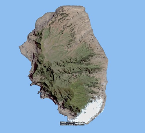
Lang-yeh Wan (Ya Long Bay) contains several islands and islets. Dongmao Zhou (18°11'N., 109°41'E.), 111m high, is the outermost island of the bay. A 14m high rock and an 11m high rock lie close E and N, respectively of the island. Hsi Chou, 105m high, lies 1 mile W of Dongmao Zhou and is marked on its SE end by a light.

Yeh-Chu Tao, an island, 95m high, stands within the bay about 2.5 miles NW of Dongmao Zhou. Two small islets, Tung-p'a and Hsi-p'ai lie to the W of Yeh-chu Tao. Anchorage can be taken in 12.8 to 14.6m, mud and sand, about 0.8 mile NE of the E end of Yeh-chu Tao. However, the NE wind blows strongly between the hills of the peninsula to the E and during S and SE winds, considerable swell may build up in the bay.

Between Pai-hu Chiao and Jinmu Jiao (Chin-mu Chiao) (18°10'N., 109°33'E.), 2.8 miles WSW, the coast is bold and steep-to. This headland marks, at Jinmu Jiao, both the S point of Hainan Dao and for descriptive purposes, the dividing line between the E and W coasts of the island. The peninsula rises to 380m to the NE of the signal station above Jinmu Jiao. A light is shown from the S extremity of this point and the coast to the W is steep-to and bold; a racon is situated at the light. (SD Pub-161; pg 66)

------------------------------

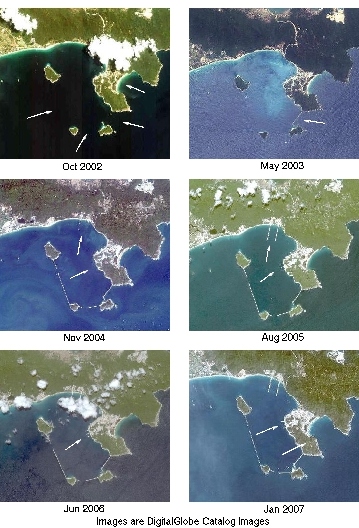
The imagery used in this exercise comes from DigitalGlobe (DG) catalog images found in Google Earth (GE). I selected the above nine images based on four factors: 1) Area of coverage, 2) Date, 3) Cloud-free and 4) Suitable Environmental Quality index (highest for the year). All of the images featured my area of interest, the islands and peninsula where the naval base is located. I had already mapped the area using both Landsat and DG imagery in GE. I identified the naval base from the numerous tags placed by GE naval snoops. They are able to easily identify ships and naval infrastructure using DG's hi-res images. So, back to our PHOTINT exercise.

The Jun 2006 DG image is the one found in GE. I did the overwhelming majority of my mapping of this area using it as my base image and supplemented with Landsat and the DG catalog images to complete my project. After assembling the above date-ordered sequence of images and we can begin the PHOTINT of our area of interest.

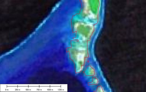
Oct 2002 - No protective breakwaters built yet. The site of the naval base is undergoing development, but the small islands scattered about the bay remain unattached.

May 2003 - A breakwater connecting the peninsula and the three southern islands has been built. Not too much other development has happened.

Nov 2004 - What a difference! All of the breakwaters are in place between the islands. The two lengthy piers, from the northern shore, are being built. Still no piers at the naval base proper.

Aug 2005 - All of the piers have been built. The two northern ones and three smaller ones at the base.

Jun 2006 - This is the DG image found in GE. The clouds obscure the two long piers. However, using the other images from previous years, I was able to map them successfully.

Jan 2007 - What happened to the middle pier? Maybe they needed more space between the two outer piers. A final observation concerns the peninsula itself. Apparently, submarines are kept beneath the peninsula. It is riddled with tunnels, some big enough for a submarine (based on GE naval snoops descriptions).

Now, wasn't that interesting? Using a little imagination, creativity, organization, ingenuity and PHOTINT skills, we all learned about the development of a portion of the Ya Long Naval Base. Imagine what the professional intel snoops are able to glean from the real hi-res images?

Enjoy!

PS - If it appears that I am treating a very sensitive and serious subject lightly, that is not my intent. All of us curious sorts that spend hours poring over DG imagery in GE conduct our own PHOTINT. We find aircraft, ships, vehicles, military sites and much more because it interests us. Perhaps in our youth, we too were snoops.

Tuesday, July 10, 2007

Thoughts - EVS Islands Top 10 Posts

Nukuoro Atoll - Map

Nukuoro Atoll - Marplot Map (1:50,000)

10 - Nukuoro Atoll FM (160) - Nukuoro Atoll NASA image was posted to a popular Korean Web Portal. Lots of people came to visit because of that exposure.


Isla Alejandra Selkirk - Map Final (1-75,000)

Isla Alejandra Selkirk - DigitalGlobe Image (1:75,000)


10 - Isla Alejandro Selkirk CI (160) - This is always a popular destination for the stressed person looking to escape the harsh rigors of city life. It is the place poor Alexander Selkirk was abandoned. He survived and his story was retold, with numerous rewrites by the author and a name change, as Robinson Crusoe.


PGS Overlay

PGS Overlay

8 - Data: Improved WVS? Rival EVS? What's Going On? (190) - Over a year ago a reader suggested I look at the Prototype Global Shoreline (PGS). NIMA has made available a global shoreline derived from Landsat ETM+ imagery. When it works, it is great. When it doesn't, it leaves one wanting more. I have discussed PGS strengths and shortcomings in a number of previous posts (see Gaps and PGS to EVS) but this first one gets lots of views.


Nikumaroro Atoll - Map (1-25,000)

Nikumaroro Atoll - Marplot Map (1:25,000)

7 - Nikumaroro Atoll KR - Third Time is the Charm (201) - This island fascinates many folks throughout the world. It is one of the possible crash-landing sites of famed aviatrix, Amelia Earhart. I liked it before I learned of the Earhart connection. The map is one of my early best efforts. I love the reef details in the lagoon.

7 - Thoughts - "EVS" Means "Whatever" (201) - A rock group out of Australia coined the hip phrase "EVS" for "Whatever". They had their moment in the limelight and I had my moment of views checking out my "EVS". They wondered about the connection between my island maps and "Whatever". Whatever.

Niau Atoll - Marplot Map

Niau Atoll - Marplot Map (1:50,000)

7 - Niau Atoll FP (201) - This is another post that got loads of views because of exposure on a portal site. The ESA image was featured on MSNBC. It peaked people's curiosity and my site became a primary destination for additional information.

4- Thoughts - To All of You Searching For "EVS, Australia" (300) - See 7 above.


Rapa Iti Island - Marplot Map (1-60,000)

Rapa Iti Island - Marplot Map (1:60,000)

3 - Rapa Island FP (378) - Another mysterious destination for the arm-chair traveller. As a boy, I read that there were 7 women to 1 man on this island. I really wanted to visit this island! Now that I know what I know, I think I'll pass. Too many complications with one woman in my life. Could you image the "honey-do's" from 7-women?


2 - Thoughts - What's Up With Niau Atoll FP? (548) - See 7 above.


B - The center of the box is where the vector is applied

Making a Map in Google Earth

1 - How to Make a Map using Google Earth's KML Format (Revised Version) (633) - People want to make maps. Thats why many folks visit my site. I'd like to think my island projects are a strong draw. They are, but they do not generate the same interest as learning how to make your own maps. Long time readers know that I work on the "cheap". The bulk of my suite of mapping software (Marplot, ImageForge, Irfanview)is free or low cost (Global Mapper -$200, Flickr - $20 per yr, Google Earth Plus - $20 per yr). My imagery is Landsat ETM+ mosaics and DigitalGlobe imagery found on Google Earth. I have spent the last four years working at my map-making craft. I'm getting better, but it is hard work with little payback. If you are serious about learning how to make accurate, attractive and inexpensive maps drop me a line and I'll share what I've learned. ANYONE can do what I do when it comes to making maps. But you must commit consistent time and energy to develop your talent.

And that's the top 10 posts. Interesting, huh?

Enjoy!


Monday, July 9, 2007

Dao Bach Long Vi VN - A Fancy Map!

Dao Bach Long Vi - Landsat Image N-48-20_2000 (1:17,500)

Dao Bach Long Vi - Landsat Image N-48-20_2000 (1-17,500)


Dao Bach Long Vi - Marplot Map (1:17,500) Original

Dao Bach Long Vi - Marplot Map (1-17,500)

I haven't posted one of these in a long time. It is an Enhanced Vector Shoreline of a Vietnamese island. It seems that I posted this before, but I'll be darned if I can find it on my site. Oh, well.

Dao Bach Long Vi is a potential Marine Protected Area. For now, it is home to a lighthouse and a very small population of fishermen.


Dao Bach Long Vi - Marplot Map (1-17,500) Fancy

Dao Bach Long Vi - Marplot Map (1:17,500) - A Fancy Map

Yes siree, this is a fancy map. I took my original map, less lat/lon and scale box, and worked it over in my free paint program, ImageForge. I am still experimenting with fonts and text (credits and such), but the overall composition looks good. It took an extra two-hours to complete this project, but it is well worth it.

View Dao Bach Long Vi on Google Maps

Enjoy!

Saturday, July 7, 2007

Little Sitkin Island US - These are "WOW" Images

Little Sitkin - View North (ISS Image)

Little Sitkin Island - View North (ISS Image Mosaic)


Little Sitkin Island US - A GE Tour


I'm not a Google Earth (GE) mashup person. The only way I could think to share my work posted in Google Earth was using screen shots. I am making use of Flickr slideshow feature. It will give you an idea on how a brief tour in GE might be.

The two images that makeup my overlay are from two ISS005 Images (18288 & 18289). I patched them together to create this virtually cloud-free image of Little Sitkin. Cloud-free and the Aleutians is a weather anomoly. If you do get a clear day, the islands are often shrouded in snow. These images are exquisite for clarity of ground detail. The images gets their 3D effect from the underlying data (SRTM/DEM) in GE. The western shoreline has been stretched to accomodate the underlying SRTM/DEM data. Consequently, the lat/lon's for that shoreline are off by a few hundred meters. If you want to make a map, you will need to get in touch with me and I'll send you a GEOTIFF image of the island. With that you can make a map.

The photos were taken during a research trip in 2005. The photographer is unidentified. Images are courtesy of AVO/U.S. Geological Survey. Please cite the photographer and Alaska Volcano Observatory / U.S. Geological Survey when using these images.

Follow this link and you can take the tour in GE.

View Little Sitkin Island on Google Maps

Enjoy!

Monday, July 2, 2007

Nikumaroro Atoll KR - Third Time is the Charm

Nikumaroro Atoll KR - Marplot Map (1-30,000)

Nikumaroro Atoll - Marplot Map (1:30,000)

This is my third time posting this. I received an e-mail from a representative of TIGHAR, a group that has visited this atoll searching for clues to the whereabouts of Amelia Earhart. He asked that I post the following information to discourage visits to the island. The only way one is allowed to visit is with permission of Kiribatian authorities. Read on.

"The best landing place, marked by a white pyramidal concrete structure, is about 0.3 mile S of the village. A boat channel has been cut through the reef in a 054˚ direction and in line with the concrete beacon. Landing should be attempted just after HW when there is less surf than on a rising tide. With a SE wind, landing can be effected in the lee of the wreck at any stage of the tide."

(Sailing Directions Pub-126)

Comment from Pat Thrasher at TIGHAR: The beacon is long gone. It was cleaned off by a storm in 1990 or so. The wreck is gone except for the shell of the triple expansion steam engine. No lee.

BUT. It is completely, utterly ILLEGAL for anyone to land there at all. It is a protected area, bird sanctuary, and about to become a World Heritage Site. No fishing, no landing, no nothing, except as sanctioned by the government of the Republic of Kiribati. We have permission and will have a Customs officer with us. No equipment may be landed without strict adherence to environmental concerns about introduction of insects, bacteria, molds, etc.

Nikumaroro is a sensitive archeological and cultural site. I hope you will discourage landings rather than promoting them with information about when and where to make them!


Nikumaroro Atoll KR

Nikumaroro Atoll (Gardner Island) (4˚40'S., 174˚31'W.) is a wooded, wedge-shaped atoll lying about 137 miles W of Orona Atoll (Hull Island). The atoll is surrounded by a fringing reef, which dries at LW, extending about 0.2 mile offshore. The NW and SE extremities of the reef appears to be extending. Depths off the atoll, which is steep-to except at its NW and SE extremities, average 366m, 0.3 mile from the reef. Nikumaroro Atoll (Gardner Island) encloses a lagoon into which there is no navigable passage. With the exception of two breaks, a large one on the W side and a narrow one on the S side, the land rim of the atoll entirely surrounds the lagoon.

The lagoon is encumbered with coral heads, but seaplanes have landed successfully.

A conspicuous stranded wreck lies close W of the N extremity of the atoll. The wreck was reportedly breaking up.

Tides—Currents.—Off the atoll the set is W, and varies in direction and strength with the prevailing wind. Close inshore, the current follows the trend of the land to the W. There is a deserted village on the W side of the atoll, about 1 mile S of the N extremity, off which anchorage may be obtained by small vessels, very close inshore. Two small beacons N of the village indicate the approach.

Directions.—The best landing place, marked by a white pyramidal concrete structure, is about 0.3 mile S of the village. A boat channel has been cut through the reef in a 054˚ direction and in line with the concrete beacon. Landing should be attempted just after HW when there is less surf than on a rising tide. With a SE wind, landing can be effected in the lee of the wreck at any stage of the tide. The reef is extremely slippery and wide, and the landing is not recommended if any equipment is to be landed or brought off. (SD Pub-126)


This is a redo of a previous post dated 2/25/2006. I wanted to bring in my current colors and include the standard images and maps (1:200,000, 1:100,000, 1:50,000 and 1:25,000). In addition, I wanted to show the Ikonos image that was used to help in digitizing the vectors that makeup this map.

If you have difficulties reading the Flash presentation, go directly to my Flickr account and check out the set of images with the same name as the title of this post.

Enjoy!

Comparison - EVS-R and WVS

World Vector Shorelines (WVS) is the default shoreline for most government produced maps. It is also used extensively by many in the commercial mapping arena to produce their products. It is an excellent vector map file that shows shorelines of the world in exquisite detail.

That said, I searched for a detailed map of the Tokelau Islands at a large enough scale that all three of the atolls (Atafu, Nukunonu and Fakaofo) could be displayed.


Google Image Search Results -  Tokelau map

Google Image Search Results - Tokelau Map


Every readily available map used the same data source for their shorelines - WVS. The best scale to display all three atolls is 1:750,000. I thought that WVS would be the ideal source - Wrong! Knowing what I know about atoll shapes and the importance of including the reef as part of the shoreline, WVS was woefully inadequate.

The answer was simple - merely create a new vector file of these three atolls. Using Global Mapper and Landsat ETM+ as base imagery, I worked at a scale of 1:62,750 and digitized the land areas and reefs of these three atolls. Using Marplot I created this new layer of mapping information called Enhanced Vector Shoreline-Rough (EVS-R).


EVS-R and WVS (1-1,000,000)

EVS-R and WVS (1-1,000,000)


EVS-R and WVS (1-250,000)

EVS-R and WVS (1-250,000)

Not only is the EVS-R a more detailed image, but it is accurately plotted at this scale. You will notice that the WVS is misplotted further north than it should be.


It is a major improvement over WVS. What do you think?


Enjoy!