Monday, September 29, 2008

Thoughts - Ultima Thule, Gravel Bars and Curiosity

pearyland_ast_2003137_lrg Mod

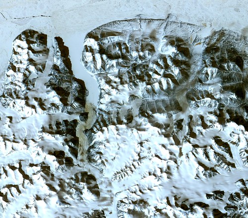
Peary Land, Greenland - The Image That Started My Search

On Sunday morning, while drinking my morning cup of coffee and checking my "usual websites", I came upon the above image of the northern shoreline of Greenland posted to NASA's Earth Observatory. I should have just kept right on moving, but I didn't. One image identified a point of land called Point Morris Jessup in the north center of the image. I decided that it would be loads of fun to check this part of the world out in more detail. About 8-hours worth of research, georectifying and jotting notes later and this is what I've learned . . .


Map Kaffeklubben Island Mod

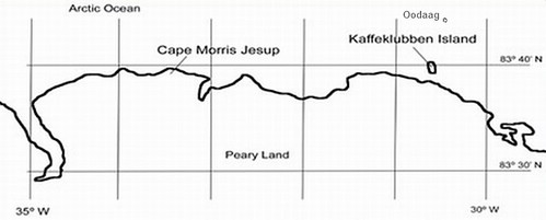
Peary Land, Greenland - Kaffeklubben and Oodaag Islands


Aerial Image of Kaffeklubben Island Mod

Kaffeklubben Island

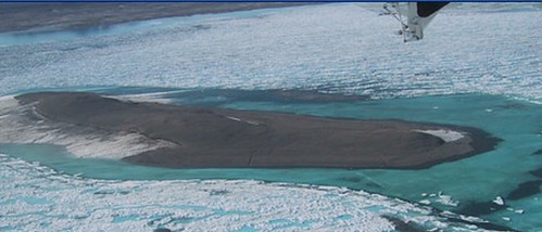
The Ultima Thule is an island. Explorers from the ancient Greeks to those within the last few years, have searched for the northernmost land, Ultima Thule. Within the last 100 years, modern explorers think they have found it located off the northern coast of Greenland. In 1900 Peary sighted Kaffeklubben Island, but never landed. A Danish explorer, Lauge Koch, landed and named this lichen splattered spot of land after a coffee bar located in a Danish museum. The above aerial photo shows an oblique view of the island. It turns out the northern tip of the island is 750-meters farther north then Cape Morris Jessup, making it the Ultima Thule.


2003 Ultima Thule Greenland in background

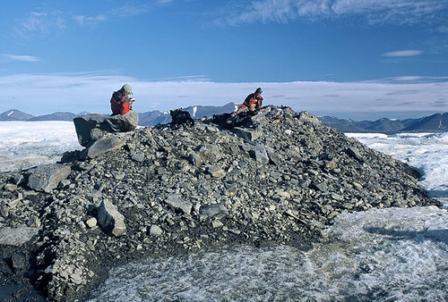
Oodaag Island - Ultima Thule?

That is until the above island, located 1360-meters north of Kaffeklubben Island, was located. Using aerial and satellite imagery, groups have pushed even farther north, by a few kilometers, finding more of these gravel bar islands.

(Before I move on I want to credit the source for the images, Arctic Thule. This site details the search for the northernmost land. It contains well written accounts of the latest efforts to identify the Ultima Thule.)

Here is my question - When is an island an island? Having mapped thousands over the past few years, I know that an island is a naturally formed area of land, surrounded by water, which is above water at high tide (per Article 121, Part 8). Based on that definition, Kaffeklubben Island is an island, but Oodaag Island is not as it comes and goes. Seems that once found in the 70's it was lost for a number of years and only recently rediscovered. It would seem that these gravel bar constituted islands to the north of Kaffeklubben Island are gravel bars first and, at best, temporary islands at least.

And finally, curiosity. I have spent way too much time on this topic. It is time to get ready for school and a classroom of middle school students. And I think I'm curious. You ought to spend time with young people, their curiosity is insatiable.

Enjoy!

Monday, September 22, 2008

Spain and Portugal - 1:100,000 Shoreline Image Tiles

Spain and Portugal Shorelines - 1-5,000,000 Landsat ETM+ Images (6-Images)

Spain and Portugal Shorelines - 1:5,000,000 Landsat ETM+ Images (6-Images)

The above image of the Iberian Peninsula is a composite made up of six Landsat ETM+ mosaics. As an island person, I'm not much interested in most of this composition. In fact, I am only interested in the shorelines plus or minus 5 to 10 kilometers.


Spain and Portugal Shorelines - 1-100,000 J2 Tiles

Spain and Portugal Shorelines - 1:100,000 J2 Tiles

So, I decided to create a shoreline image of the Iberian Peninsula. I first tried creating a series of 1:50,000 scale images of the coastline. It took way too many images and the scale did not include enought shoreline detail. I upped the scale to 1:100,000 and systematically created a series of 120 tiles to cover Spain and another 51 tiles to cover Portugal. Whereas the Landsat ETM+ images are 865 MBs in size, the 1:100,000 tiles for the entire Spanish and Portugese shorelines are 190 MBs in size (each tile about 1 MB).


N-31-40_2000 (100) ES - 010 J2 (1-400,000)

N-31-40_2000 (100) ES - 010 J2 (1:400,000)

Let's zoom in and see what one of these shoreline tiles allows us to view. Keep in mind the resolution is 14.5 meters per pixel. So here it goes...

N-31-40_2000 (100) ES - 010 J2 (1-100,000)

N-31-40_2000 (100) ES - 010 J2 (1:100,000)


N-31-40_2000 (100) ES - 010 J2 (1-50,000)

N-31-40_2000 (100) ES - 010 J2 (1:50,000)


N-31-40_2000 (100) ES - 010 J2 (1-25,000)

N-31-40_2000 (100) ES - 010 J2 (1-25,000)

How about that zoom capability? If the 1:100,000 image were of a shoreline I wanted to digitize, it would work just fine. I typically do most of my digitizing work at 1:25,000 to 1:12,500. These tiles would allow the end-user the ability to zoom into shorelines at sufficient scale to accomplish EVS precision shoreline mapping.

If you are interested in Spanish or Portugese shoreline mapping work, these 1:100,000 scale image tiles would do the trick.

Enjoy!

Sunday, September 14, 2008

Melilla Border Fence Limits Study

puerto_101-0127_IMG

Melilla Enclave

I enjoy enclaves. The Portugese scattered these trading ports along the costs of Africa and India. The Spanish were more into settling, however in the case of Morocco, they established enclaves - Ceuta and Melilla. Above is an aerial photo of the limits of Melilla looking from the port toward the northwest.


Melilla Enclave Border Fence Limits Study - Landsat ETM+ N-30-35_2000 (1-40,000)

Melilla Enclave Border Fence Limits Study - Landsat ETM+ N-30-35_2000 (1:40,000)


Melilla Enclave Border Fence Limits Study - DigitalGlobe Image from Google Earth (1-40,000)

Melilla Enclave Border Fence Limits Study - DigitalGlobe Image from Google Earth (1:40,000)

Using the above two base image sources, I created a shoreline map of Melilla. Working first off of Landsat, I created a rough EVS precision shoreline map. Working with DigitalGlobe imagery from Google Earth, I decided to not only track the shoreline using 1-meter resolution imagery, but also to determine the course of Melilla's border fence.


Melilla Enclave Border Fence Limits Study - DigitalGlobe Image from Google Earth - The Border Fence

Melilla Enclave Border Fence Limits Study - DigitalGlobe Image from Google Earth - The Border Fence


Melilla Enclave Border Fence Limits Study - BBC Image_40847408_twosides220afp

Melilla Enclave Border Fence Limits Study - BBC Image_40847408_twosides220afp

Back in 1977, I travelled to Berlin on business. While there, I visited Checkpoint Charlie and viewed the Berlin Wall. I hated that wall! It stopped what should have been normal flow of peoples and goods within Berlin. I get the same feelings when I look at the Melilla Border Fence. It was built to keep Africans out. Not only out of Melilla, but ultimately out of Europe. It seems the "Haves" cannot accomodate the "Have Nots". The world just has too many hungry people for all of us to care for. I'm sorry. I'll get off of my soapbox and get back to my map.


Melilla Enclave Border Fence Limits Study - EEVS Precision Map (1-40,000)

Melilla Enclave Border Fence Limits Study - EEVS Precision Map (1:40,000)

My international borders come from the NGDC Coastline Extractor. Specifically from the dataset called WDBII International Borders. These borders are used in many global mapping packages. They work, kind of. In my above map I traced the Melilla Enclave Border Fence from start to finish. I'm not sure if that represents the actual border between Melilla and Morocco, but it seems pretty final to me. My Melilla map shows the WDBII borders (orange line) and the fence line (green line).

So, if you want to create the definitive Melilla - Morocco border, I'd say the fence line seems to be a natural dividing line. I wait for the day border fences that separate people unnecessarily can be removed and allow us to move freely as we wish and as we should.

Enjoy!

Tuesday, September 9, 2008

Musandam Peninsula OM - The Peninsula of Peninsulas

iran_strait_of_hormuz_2004

The Strait of Hormuz - US Government Map


Oman - Landsat ETM+ N-40-25_2000 (1-1,000,000)

Strait of Hormuz - Landsat ETM+ N-40-25_2000 (1-1,000,000)

Let's begin this post with an image of a US Government map of the Strait of Hormuz, followed by a Landsat ETM+ image of the same area. Iran is to the north and Oman and the UAE are located to the south. Extending into the Strait of Hormuz from Oman is a rather odd shaped peninsula. It is called the Musandam Peninsula. It is the subject of my latest EVS Precision mapping efforts.

I teach early Greek history to middle school students. Every year I show them the Greek landform I call the "Peninsula of Peninsulas". You and I know it as the Peloponesian Peninsula. It contains four distinct peninsulas. Now let's take a look at the Musandam Peninsula.


Oman - Landsat ETM+ N-40-25_2000 (1-175,000)

Musandam Peninsula OM - Landsat ETM+ N-40-25_2000 (1-175,000)


Oman - EVS Precision Map (1-175,000)

Musandam Peninsula - EVS Precision Map (1-175,000)

My conservative count of the peninsulas within this peninsula is 12 to 13. The shoreline of the map does not do the complexity of this peninsula justice. I mapped the entire shoreline of this portion of Oman at 1:12,500 scale. To appreciate the shoreline complexity, one should zoom into this twisted piece of real estate using Landsat ETM+ imagery. Google Earth and Google Maps contain the Landsat imagery for this area. The digitizing took in excess of 12-hours to complete.

Located on the northern coast of the Musandam Peninsula is a city of 3,000 hardy souls. The small city of Kumzar, where people speak Kumzari, was isolated from the rest of Oman until recently. The people fished and stayed connected with the other Omanis by sea. Now days, they are able to use a helicopter to fly to and from the larger Omani cities. NPR has an interesting news piece that shows pictures and contains first hand information about Kumzar. Apparently the area offshore of Kumzar is highly regarded as a dive site. This website has a number of shoreline and underwater photos of the area around Kumzar.

During the brutally hot summer months, the Kumzarians, leave their northern home and travel to Khasab which has more tolerable summer weather. After summer has gone and milder weather returns, they go back to their isolated northern village.

Enjoy!