Sunday, April 19, 2009

Comparison - NGA PGS to EVS Precision Vectors

Comparison - NGA PGS to EVS Precision Vectors (1-6,250)

Comparison - NGA PGS to EVS Precision Vectors (1:6,250)

I know a good deal about global shoreline vector files. Specifically, global shoreline vector files that are free, available to the public and relatively easy to load and work with. This post's focus is a comparison of NGA's Prototype Global Shoreline (PGS) to Enhanced Vector Shoreline (EVS) Precision shorelines. This is not my first comparison of these two shorelines and it probably won't be my last, but here it goes.

NGA PGS vectors too often wobble off of the imaged coastline unnecessarily. The NGA PGS vectors were derived from Landsat ETM+ imagery, the same imagery I use to create EVS Precision shorelines. The above image is a small portion of Somalia's shoreline. The Landsat image is cloud free and the shoreline is easily distinguishable. NGA PGS used a complicated formula to determine the shoreline, but I don't see why their vectors misplot by as much as 41 meters from the imaged shoreline. No, this doesn't happen all of the time, but it happens enough, that if I am working at very large scales (1:50,000 to 1:12,500), I must redo the shoreline. Their shoreline is too far from image shoreline true.

I've been doing EVS Precision mapping for over 9 going on 10 years and my opinion concerning NGA PGS has not changed. Don't get me wrong, NGA PGS is the most detailed global shoreline available, one that I recommend heartily. However, for my work, creating detailed island maps, it isn't good enough.

Enjoy!

Saturday, April 18, 2009

Jasiira Mayhd SO - A Home for Pirates or A Home for the Birds?


View EVS Islands Projects in a larger map


Jasira Maydh - Landsat ETM+ Image N-38-10_2000 (1-25,000)

Jasira Maydh - Landsat ETM+ Image N-38-10_2000 (1:25,000)


Jasira Maydh - EVS Precision Map (1-25,000)

Jasira Maydh - EVS Precision Map (1:25,000)


SO002 JASIIRA MAYDH

Country/Territory

Somalia


Administrative region(s)

Sanaag


Central coordinates

47o 15' East 11o 14' North Map


Area

45 ha


Altitude

0 - 124m


Criteria

A4i, A4iii

Site description Jasiira Maydh or Mait island is located in the Gulf of Aden c.13 km offshore, to the north of the town of Maydh and hence adjacent to Daalo (site SO003). It is a little over 1.5 km in length with a maximum width of 300 m and an average height of 100 m. The long axis of the island is oriented from east-north-east to west-south-west. The island is steep-sided, rising abruptly out of the sea, and along the southern face rocky buttresses alternate with scree-filled gullies while the northern face is an unbroken precipice. The rock is granitic gneiss which is covered with guano deposits, and the surface is split in places by great fissures. The island is completely lacking in vegetation and there is no fresh water except after rain, of which there is only c.50 mm per year. The island lies within an area of seasonal coastal upwelling.

Land-use and percentage cover

other

-


Birds See Box for key species. In addition, Phalacrocorax nigrogularis has been recorded while other breeding species include Phaethon aethereus, Sula dactylatra, Sterna fuscata and S. anaethetus (the latter two in 'large numbers'). In the 1940s, the numbers of breeding birds present was estimated at c.100,000, but were reported then to be declining. The breeding season is June-September, after which nearly all birds leave.

Species

Season

Year

Min

Max

Quality

Criteria

Brown Noddy (Anous stolidus)breeding19792000020000-A4i
A4iii (Species group - waterbirds)breeding000unknownA4iii

Conservation issues The island has been proposed as a marine protected area. Guano is collected from the island, but traditionally only from October to April, i.e. when the birds are absent. During the breeding season the seas are generally too rough to permit boats to land, which prevents disturbance. Rats and snakes are present on the island.

Citation BirdLife International 2008 BirdLife's online World Bird Database: the site for bird conservation. Version 2.1. Cambridge, UK: BirdLife International. Available: http://www.birdlife.org (accessed 19/4/2009)

__________________________________________________________________

Yes, I nabbed the above information from Birdlife International. It makes sense that an island would figure in as a safe habitat in the world of birds. Islands are typically safe havens for many of our feathered friends.

Mayhd town, located about 10 kms to the south of Mayhd Island is reputed to be one of many pirate strongholds along this coast of Somaliland. I suspect that if pirates use this island it would be as a shield prior to attacks on ships. May the pirates disappear and the birds remain forever.

Enjoy!

Friday, April 17, 2009

How To Make A Really Big Map

New Britain Island - Landsat ETM+ S-56-00_2000 Image Resized (1-375,000) Northwestern End

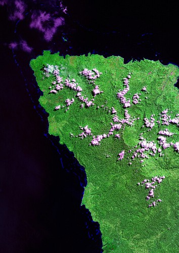
New Britain Island - Landsat ETM+ S-56-00_2000 Image (1-375,000) Northwestern End


New Britain Island - EVS Precision Map (1-75,000) Northwestern End

New Britain Island - EVS Precision Map (1:75,000) Northwestern End (Select image to see full-size)

I'm such a pushover when it comes to reader-requested mapping projects. Some of the projects are relatively simple (a single island with a couple of layers of information), others more complex (a single island with many layers of information) and finally the very complex or lengthy mapping project consisting of many layers of information or covering a large area with a variety of detail. My last mapping project, the northwestern end of New Britain Island, covered a large area and the reader was keenly interested in the offshore reefs.

Back in January 2009 the reader's initial query was deceptively simple, "Have you done any reefs in New Britain, Papua New Guinea?" During the summer of 2008, I had mapped all of the islands located between and including Papua New Guinea to the Cook Islands which consisted of over 10,000 island polygons using Landsat ETM+ as my base imagery. One of those islands was New Britain. I figured the project would be a snap. The reader was only interested in the northwestern end of New Britain. I would ensure my original island polygon was sufficiently accurate and then I would digitize and classify all reefs into a single vector layer called Reef Shallow. No problem!

Along with trying to be an attentive husband, loving father, generous grandfather, concerned and effective teacher and all-around good guy, my life got very busy. So busy that the New Britain Reef project got pushed behind my busy life. I informed the reader that I would have to table his project for the time being and since the project was "gratis", he waited. And so the New Britain Reef project resided in my computer waiting for my return. All of the shoreline was finished along with a portion of the reefs. My initial work had taken about 20-hours to complete. The week before last, the patient reader asked if I would have an opportunity to complete the project. Frankly, I had forgotten about it. Feeling guilty for not completing it way back when and knowing that I had a week's vacation coming, I promised to finish the project. And I did! It took about 10 more hours, but I finished it!

I studied my completed work and realized that this mapped area was really large. Since this reader did not require my vector files, I would have normally sent the reader a screenshot (raster image) the size of an 8.5 X 11 page of their project and that would be the end of it. However, this reader would be unable to appreciate the detailed reef information at that scale (1:350,000). I decided to construct a large format map at a scale of 1:75,000 giving the reader sufficient detail for his ultimate purpose, finding new fishing locations.


New Britain Island - EVS Precision Map (1-75,000) Northwestern End with Grids and Labels

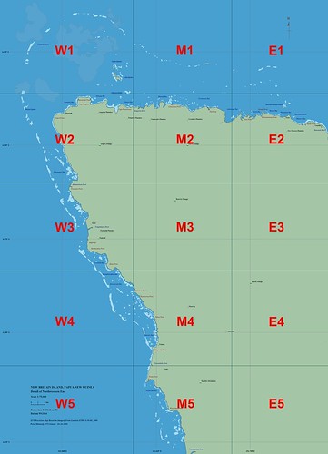
New Britain Island - EVS Precision Map (1-75,000) Northwestern End with Map Tile Labels


W3

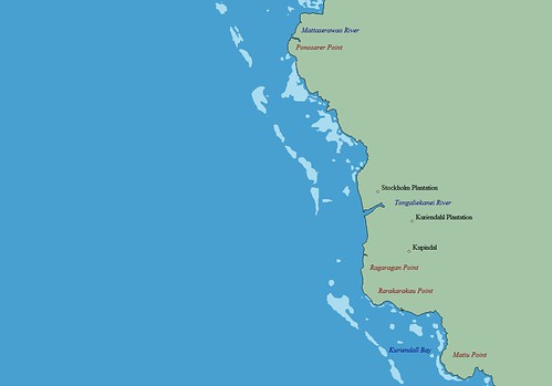
1 of 15 EVS Precision Map Tiles (W3)

I have constructed numerous image mosaics, but never a map mosaic. Using images from Global Mapper and mosaicking them into a single image using Image Forge software and finally constructing lat/lon grid lines in MS Draw, I created "a really big map" (thus the title of this post). All of you mapping professionals, calm down. I know mapping software exists that will make "a really big map" in a single step. Typically, it costs money and that's something I don't have much of. Anyway, back to my mosaicked map. "The really big map" consists of 15 tiles , each tile similar to the one displayed in the above image. My final map is 3050 X 4220 pixels in size or about 65 x 89 cms (25.5" x 35").

My final thought, I've got to start charging for my work! I spent 30+ hours on this project. At a modest fee of $20 per hour, I should have made $600 for this project. Instead, New Britain Island's northwestern end is mapped in great detail and I'm none the richer for it.

Enjoy!

Wednesday, April 15, 2009

Musandam Peninsula OM - A Revisit of a Previous Post


View EVS Islands Projects in a larger map


Oman - Landsat ETM+ N-40-25_2000 (1-175,000)

Oman - Landsat ETM+ N-40-25_2000 (1:175,000)


Oman - EVS Precision Map (1-175,000)

Musandam Peninsula - EVS Precision Map (1-175,000)


Musandam Peninsula - EVS Precision Map with 50-Meter Contour Intervals (1-175,000)

Musandam Peninsula - EVS Precision Map with 50-Meter Contour Intervals (1:175,000)

The above EVS Precision map project of the Musandam Peninsula was completed around the first week in September 2008. It was my last mapping "hurrah" before the start of this school year. I remember loving the look of this unusual piece of land calling it a "peninsula of peninulas.


Musandam Peninsula Oman from EO (musandam_AST_2004067_lrg) Resized

Musandam Peninsula, Oman from Earth Observatory (EO)

It seems that the folks at EO dusted off a 2004 ASTER image of the Musandam Peninsula and posted it to their site today. The peninsula is still lovely to look at!

Enjoy!

Monday, April 13, 2009

The Great Blue Hole Located on Lighthouse Reef, Belize


View EVS Islands Projects in a larger map

Great Blue Hole, Belize Resized (greatbluehole_ali_2009083_lrg)

Lighthouse Reef and The Great Blue Hole from Advanced Land Imager (ALI) on NASA’s Earth Observing-1 Satellite

On April 3rd the above image was posted to Earth Observatory's Image of the Day. I read the article with mild interest. I was aware of the these features, cenotes, being found throughout this part of the world. After downloading the 4 MB image of the entire reef, I figured that it would be an excellent island mapping project. I checked out the Landsat ETM+ image and it is cloud free and quite detailed. So, I began to map it.


Great Blue Hole - Comparison Landsat to ASTER Images

Lighthouse Reef and the Great Blue Hole - Comparison Landsat to ASTER Images

The small cays that are located on the reef at first glance looked to be fairly simple. They were not! Wanting to do justice to the details shown on the base image, my digitizing was ultimately complex. I worked at scales between 1:25,000 to 1:12,500 for most of my digitizing.


Lighthouse Reef and The Great Blue Hole, Belize - Landsat ETM+ N-16-15_2000 Image (1-220,000)

Lighthouse Reef and The Great Blue Hole, Belize - Landsat ETM+ N-16-15_2000 Image (1-220,000)


Lighthouse Reef and The Great Blue Hole, Belize - EVS Precision Map Preliminary (1-220,000)

Lighthouse Reef and The Great Blue Hole, Belize - EVS Precision Map Preliminary (1-220,000)

10-days and about 20-hours later, I am done. All of the layer colors used are my usuals, except for the ocean layer. I went with a darker blue. In my opinion, the deep blue ocean color accents the many shades of blue used in detailing the reef system.


Great Blue Hole (National Geographic) belize-blue-hole-reef-731526-sw

Great Blue Hole from National Geographic

If you are curious about this feature follow the links found throughout this post. Wikipedia also has an informative article about the Great Blue Hole you might find interesting.

From a mapping perspective, I am pleased with my finished product. However, to truely appreciate the amount of detail included on the map one needs to study the vector map. It is really cool! Oh, well...I'm glad it's done. Now on to the north coast of New Britian and more reefs.

Enjoy!