Turkey - SRTM with EVS Vector Modifications
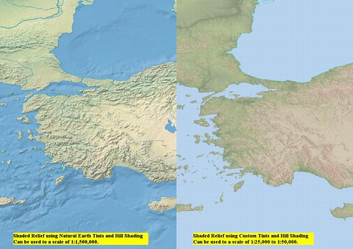
The map of Turkey on the left is a portion of a 600-MB World Map created by Tom Patterson. His excellent and informative website, Shaded Relief, contains a wide variety of shaded relief maps. He explains how you could create your own shaded relief maps. I have been content to download his finished maps and use them in my classroom. The students love working with them.
I have been a long time user of SRTM data. Using tools within Global Mapper, I was able to generate interesting 3D views of islands. Last week I came across SRTM v4 data at CGIAR Consortium for Spatial Information (CGIAR-CSI), which I call Cigar (See-gar) for short. I downloaded a number of SRTM TIF images covering Turkey, where I am plotting Roman era towns and cities. Using the Shaded Relief Natural Earth 1 world map I was able to plot at scales of 1:1500000 to 1:1000000. When I attempted to work closer the map became a screen full of pixels. What to do?
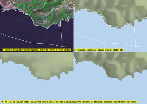
Marmara Island - SRTM EVS Modifications Before and After (1:25,000)
The SRTM v4 data offered me some intriguing possibilities. First, I was able to zoom into areas at scales between 1:500,000 down to 1:50,000. At 1:50,000 I had to contend with pixels. The vertical side of a pixel in the part of the world I am working in is 90 meters, the horizontal side is 70 meters. Clunky looking when working at 1:50,000. It was then that I had my "ah-ha" moment. I loaded Landsat imagery on top of the SRTM imagery. I then digitized shorelines using the Landsat imagery (section 1). I switched off the Landsat imagery and my EVS precision shoreline cut through SRTM v4 pixels (section 2) and allowed me to determine the shoreline on the SRTM image. The SRTM modified shoreline is now useful to scales as fine as 1:25,000 (section 4).
I know! A 14.5 meter pixel defining a 90-meter pixels leads to potential problems. However, for my purposes, plotting Roman era towns and cities, these SRTMs modified with EVS precision shorelines work just fine.
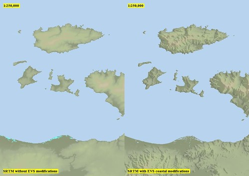
Marmara Island Vicinity - SRTM with EVS Modifications Before and After (1-250,000)
And at 1:250,000, they look great!
A word about my custom hypsometric tints. The colors I initially took from the Shaded Relief website. But I have since tweaked them a number of times. The current version, certainly not my last, looks great for this part of the world.
I am slowly, but surely working my way around the shoreline of the Sea of Marmara, a place I spent time as a young man. I do hope this was both informative and interesting.
Enjoy!