Friday, February 27, 2009

Thoughts - Tahiti-Pacifique and Alex W du Prel

Tahiti Pacific - BannerEvery so often I encounter a reader that shares first-hand information about an island I've mapped. An individual shared that an entrance to one atoll was no longer marked, as described by the Sailing Direction Pub 126. Another recounted their adventures, as a much younger person, planting coconut palms on a hurricane devastated atoll. And another shared observations while visiting Rapa Iti. All of these contributions are always welcome and, when appropriate, are shared with my readers.

That brings me to Alex W du Prel. He is a follower of my work and recently began sharing information that will bring my posts to a more current and accurate state. He is the publisher of the Tahiti-Pacifique Magazine.


Tahiti-Pacifique - Cover

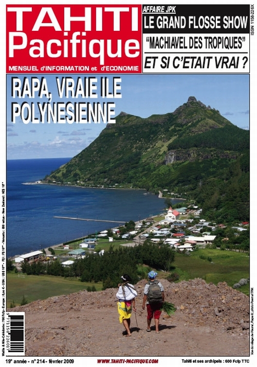
The cover of the latest edition of Tahiti-Pacifique

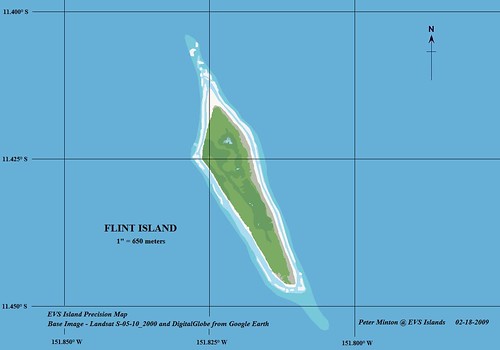
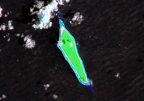
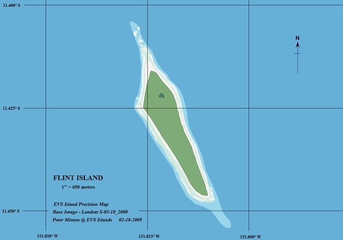
Alex recently shared great information about Flint, Vostok, Eiao and Rapa Iti Islands. The information is typically derived from articles found in Tahiti-Pacifique. Along with the published information, he shares his personal on-island experiences as well.

In this age of digital information and the demise of the printed word, Tahiti-Pacifique offers one printed glimpses of Pacific islands. The articles are written in French (and no, there is no English language edition) and include gorgeous photos of the subject islands.

I frequently gather island information from two highly reliable sources: 1) Sailing Directions Pub 126 covering the Pacific Ocean and 2) Atoll Research Bulletin. Both are great sources of information for islands and specifically Pacific islands. The Sailing Directions give up-to-date maritime information and the Atoll Research Bulletin contains scientific research derived from expeditions at specific atolls. In the future, I shall include island information derived from Tahiti-Pacifique and Alex, its editor, as a reliable, highly competent source for island information.

Drop him a line and share your island interests. Best of all, subscribe to Tahiti-Pacifique and help to keep this window into the world of islands open.

Enjoy!

Wednesday, February 25, 2009

Flint Island KR - A Line Island Paradise Redo


View Larger Map
Flint Island - EVS Precision Map (1-650-m) 1

Flint Island - EVS Precision Map (1":650-meters)

I have taken my original EVS Precision map and made it better. Using the DigitalGlobe image from Google Earth, I was able to add 4 small ponds. They are full of brackish water. It is said one could drink the water, but it is on the salty side.

During a circa 1974 expedition a fire was started. It burned a native stand of Pisonia Grande trees and smoldered for a few years. It is finally out, but the fire did lasting damage. However, deep damage was done to this small island during the late 19th century - that's when guano was mined. The mining leaves scares that deep into the island's surface.

I believe the above map is a significant improvement my original mapping efforts.

Enjoy!

P.S. - Thanks to Frank at Google Earth Blog for the reminder - "Please include an embed GE Map to help readers locate your mapped islands". Frank's a good man and offers helpful advice in a kind and gracious manner.

Thursday, February 19, 2009

Flint Island KR - A Line Island Paradise?

Flint Island - Landsat Image S-05-10_2000 (1 - 650 meters)

Flint Island - Landsat Image S-05-10_2000 (1" - 650 meters)


Flint Island - EVS Precision Map (1 - 650 meters)

Flint Island - EVS Precision Map (1" - 650 meters)


Wagner IV World - Flint Island

"Flint Island is located about 740 kilometers (400 nautical miles) northwest of Tahiti, 190 km (100 nautical miles) south-southeast of Vostok Island, and 220 km (120 nautical miles) southwest of Caroline Island. The island is about 2.5 miles (4.0 km) long and 0.5 miles (0.80 km) wide at its widest point (4.0 by 0.8 km). It has a land area of 1 mi² (3 km ²) and rises to a height of 25 feet (8 m) above sea level. The island is surrounded by a narrow fringing reef and with no safe anchorage landing is difficult.

According to the U.S. Exploring Expedition (February 5, 1841), the island was thickly wooded, however the island is now mostly covered with planted coconut palms."

The above infornmation is taken from Wikipedia. The article contains a wealth of information about Flint Island. But my interest is different. My interest is about making a map of this island quickly, accurately and a quality presentation.

Here is the background. I will respect the privacy of the names of individuals contacting me and the publications they represent. I got an email today from a well-known individual representing a stellar publication gathering information on the Line Islands. I have done some mapping in this island group. I have not mapped Flint Island. I figured that I would map it and share my finished project with this individual. Certain they will be impressed by this effort, perhaps my maps might end up in this stellar publication's pages. Just maybe. Oh well, if nothing comes of this effort, I have made an interesting map and I like it. I hope all of you...

Enjoy!

.

Monday, February 16, 2009

Thoughts - Creating Little World Locator Maps

Wagner IV World - Plotted Project

Here is a Little World Locator Map in action. This one was created using a tool called the Global Map Projector. It is supplied by the Goddard Institute for Space Studies and is located in an area called Software Tools. It is freeware. One needs only to download and extract the files into their work area. Then it's a double-click on the G.Projector and follow directions. It does require Java in order to operate. Using the supplied sample world maps, one can create any number of global projections and center them to any longitude they desire. For example, the Little World Locator Map I created is a Wagner IV projection, centered on 150°E longitude. I'm not real crazy about the color and size of the locator dot, but I'll take care of that later. The important thing is, my Little World Locator Map looks pretty good. G.Projector is really a cool too!.

Oh, by the way, I am actually working on digitizing reefs off of the northern end of New Britain Island on this rainy Monday afternoon.

Enjoy!

Sunday, February 8, 2009

Thoughts - Locating EVS Island Map Projects on Little Worlds

NASA EO Image Location Map

NASA Earth Observatory Image Locator Map

NASA's Earth Observatory is one of my favorite sites. They not only post interesting imagery, but the text explaining the imagery is intelligent, challenging and understandable to the layman. It is a consistently great read. Some time back they revamped their site look and began using an image locator map. I've tried many types of locators for my maps and have not been thrilled with any. Google Maps, which I post to the top of my site, works but not for me. I spend too much time exploring and not enough time making island maps. I had chopped a black and white world map into 3 sections and used the sections when appropriate, but it just didn't work for me. After looking at EO's solution the answer might be to use a copyright free little world map as an island map locator. Two questions remain, Are there any copyright free little world maps available? and Which one will work best for my purposes?


Little EO World 250NASA's Little World

I like this little world. The projection works and the color scheme is easy on the eyes. Adding my "island map is here" symbol would work on this map. I have tried to contact the NASA EO webmaster to see if this map is copyright free. To date, the individual has not answered my question. I suspect it is copyright free as almost all of NASA imagery has moved in that direction. Until I get an official answer from an official NASA webmaster, no dice on this map.


World Map grey 250Wikimedia Commons Little Grey World

Originally posted as an SVG formatted world map in Wikimedia Commons, this map intrigues me. First it is Pacific centered. That is a major plus for plotting my work as the majority of the islands I map are located in the Pacific Ocean. The Indian Ocean is also well displayed. The Atlantic Ocean has few islands and those that I would map could be made to show up on this little grey world. This map is definitely in the running as my Little World Island Locator Map.


World Map 250Wikimedia Commons Little Mercator World

Another Pacific centered map that divides the world at the Indian Ocean. I love the color scheme on this map. The yellow land masses show well against the soft blue oceans. The lan/lon grids do not seem to clutter the map. This map could definitely work as my Little world Island Locator Map.


Map_projection-Eckert_IV Pacific Centered 250Wikimedia Commons Little Eckert IV World

This little world is my favorite. I like the dusty yellow and blue color scheme. The lat/lon grids are a definite plus. The map is copyright free. I think I'm going to give this little world a try as EVS Islands newest feature, the Little World Island Locator Map.

Enjoy!

Wednesday, February 4, 2009

Ailuk Atoll RMI - 49 Named Motus Out of 57

Ailuk Atoll - Locator Map from ARB-127

Ailuk Atoll - Locator Map from ARB-127


Ailuk Atoll - From ARB-127

Ailuk Atoll - Map From ARB-127

Just a few more atolls to map to complete the Republic of Marshall Island (RMI), specifically the Radak Chain. This particular island is made up of 49 named motus out of 57 total. I labeled a few of the larger motus. The atoll is home to 488 people. They make their living from harvesting and the sale of copra, fishing andcatering to the few tourists that come their way.


Ailuk Atoll - Landsat Image N-59-10_2000 (1-165,000)

Ailuk Atoll - Landsat Image N-59-10_2000 (1:165,000)


Ailuk Atoll - DigitalGlobe Image from Google Earth (1-165,000)

Ailuk Atoll - DigitalGlobe Image from Google Earth (1:165,000)

I began this mapping project using the Landsat image. The clouds obscure many of the motus and underlying reefs. I checked out Google Earth's imagery and found the above DigitalGlobe image. First I constructed an image mosaic from the DG data, georeferenced it using my Landsat image. Once finished, I digitized the following layers of information: Island Polygon, Vegetation, Reef Awash, Reef Break, Reef Shallow and finally Reef Deep. Due to the size of this atoll and to display the entire atoll on one page required a scale of 1:165,000.


Ailuk Atoll - EVS Precision Map (1-165,000) 1

Ailuk Atoll - EVS Precision Map (1-165,000)

And here is the finished map. I only labeled the larger motus. The map took about 10 hours to complete. The motus were mapped primarily using DG images from Google Earth except in the southern part of the atoll where no DG imagery is posted. Whereas the reefs were mapped primarily from Landsat N-59-10_2000 imagery.

I finished the map at 12:00 AM this morning. At the time, the map and the post looked pretty good. This morning I had to make a number of corrections to both the post and the map. A word of advice, don't map after midnight. Your judgement gets cloudy and can obscure your normally keen perception.

Enjoy!