Wakhjir Valley & Pass AF
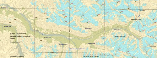
Wakhjir Valley and Pass - EVS Precision Map N-43-35-2000 from Landsat ETM+ N-43-35-2000 (1-100,000)
This map is the culmination of over two weeks of digitizing glaciers, meandering streams, high mountain meadows and many hours of research. During the researching phase I learned about the Great Game, Marco Polo sheep and the Hindu Kush, Pamir, Karakoram mountain ranges. I learned that this valley is an offshoot of the primary valley, the Wakhan that slices between the Pamirs to the north and the Hindu Kush to the south. At the Wakhan's eastern terminus, one could head into the Wakhjir valley and cross over the Wakhjir Pass into China or one could continue east to northeast into Tajikistan and eventually into China. I have always liked the path less traveled, so I elected to study and map the Wakhjir Valley and Pass, a trekkers paradise.
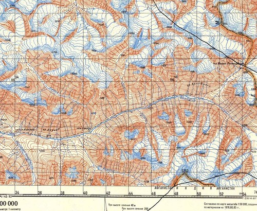
Wakhjir Valley and Pass from Russian Topo J-43-101
First in conducting research, I discovered a site, Poehali!, offering 34,727 free Russian topographic maps (1:100,000). Not only do they offer the topos, but a corresponding MAP file to facilitate georectification. Like a kid in a candy story, I downloaded 11 topos with MAP files. I'm not the greatest at reading cyrillic, but using Google Translate, while comparing the topos to both Landsat ETM+ N-43-35-2000, which covers all of my target area and Google Earth imagery, I was able to make sense of the written data included on the topos.
During my study of the topos, I determined that the Russians had digitized the international borders with a greater accuracy than any of my border sources. Using their topos as base imagery, I digitized new international borders for this area.
The 100-meter contours were generated using void filled SRTM files and Global Mapper. They took about 30-seconds to create once all of the necessary files were loaded. The Russians used 40-meter contours. I think that is overkill. So I elected 100-meter contour intervals.
See all of the glaciers, meadows and streams? That's what took many hours to digitize. All of this data was taken from the Landsat ETM+ N-43-35-2000 imagery. It is virtually cloud free and snow free leading me to believe the imagery was taken during the short summer. It was a matter of how detailed I wanted my map to be. The glaciers were tedious to digitize. I was able to map all glaciers and snow banks that were imaged. The streams were the easiest to map and the least accurate. Landsat, at 14.5 meter resolution, makes that mapping difficult. If the streams/rivers branched, I created a layer called meandering riverbed. My final polygon layer high mountain meadows. The people living in this part of the world are herders. These mountain meadows are critically important as food for their domesticated animals, sheep and goats. These mountain meadows consisted of the lime-green colored vegetation layer located along the valley floors. Needless to say, these three polygon layers were challenging to map and time-consuming to digitize. I wanted to stop and move on to an island, but I counldn't bring myself to do it. Today, I am done! The map can still use work, but I am done.
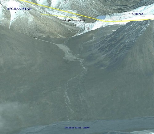
Wakhjir Pass - Google Earth Pro Image
The above image shows the climb one would need to make in order to get to the pass and cross into China. Apparently, Marco Polo is reputed to have crossed at Wakhjir Pass on his historic trip into China. On the way he recorded a description of the sheep that takes his name, the Marco Polo sheep
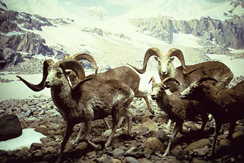
Marco Polo Sheep (picture from Snow Leopard Conservancy)
Their numbers are dwindling due to lose of habitat, over hunting and weather extremes. George Schaller has worked tirelessly to save these endangered animals. He would rather not have these majestic animals hunted, but if they must be then the hefty fee of $25,000 per hunt, should be used to benefit the people of the Wakhan. He also is working to establish a 50,000 sq kilometer multinational park that will go far in protecting the Marco Polo sheep and their unique habitat.
Finally, for all of you visiting my site expecting to see my latest island map, I apologize and will endeavor to remedy the situation. For all of you who appreciate a nice map, select the top map image and see the map at full size. Pretty cool, huh?
Enjoy!
No comments:
Post a Comment