
The Strait of Hormuz - US Government Map
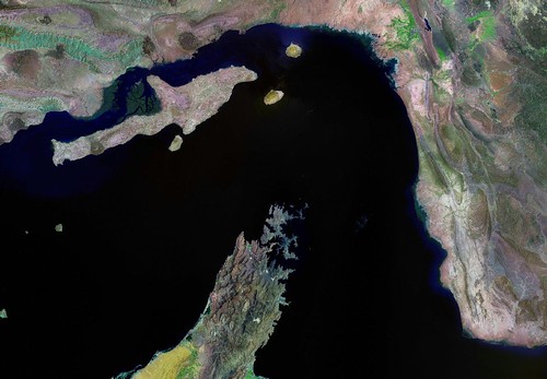
Strait of Hormuz - Landsat ETM+ N-40-25_2000 (1-1,000,000)
Let's begin this post with an image of a US Government map of the Strait of Hormuz, followed by a Landsat ETM+ image of the same area. Iran is to the north and Oman and the UAE are located to the south. Extending into the Strait of Hormuz from Oman is a rather odd shaped peninsula. It is called the Musandam Peninsula. It is the subject of my latest EVS Precision mapping efforts.
I teach early Greek history to middle school students. Every year I show them the Greek landform I call the "Peninsula of Peninsulas". You and I know it as the Peloponesian Peninsula. It contains four distinct peninsulas. Now let's take a look at the Musandam Peninsula.

Musandam Peninsula OM - Landsat ETM+ N-40-25_2000 (1-175,000)
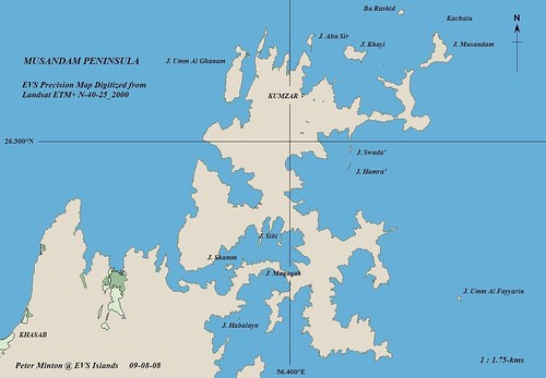
Musandam Peninsula - EVS Precision Map (1-175,000)
My conservative count of the peninsulas within this peninsula is 12 to 13. The shoreline of the map does not do the complexity of this peninsula justice. I mapped the entire shoreline of this portion of Oman at 1:12,500 scale. To appreciate the shoreline complexity, one should zoom into this twisted piece of real estate using Landsat ETM+ imagery. Google Earth and Google Maps contain the Landsat imagery for this area. The digitizing took in excess of 12-hours to complete.
Located on the northern coast of the Musandam Peninsula is a city of 3,000 hardy souls. The small city of Kumzar, where people speak Kumzari, was isolated from the rest of Oman until recently. The people fished and stayed connected with the other Omanis by sea. Now days, they are able to use a helicopter to fly to and from the larger Omani cities. NPR has an interesting news piece that shows pictures and contains first hand information about Kumzar. Apparently the area offshore of Kumzar is highly regarded as a dive site. This website has a number of shoreline and underwater photos of the area around Kumzar.
During the brutally hot summer months, the Kumzarians, leave their northern home and travel to Khasab which has more tolerable summer weather. After summer has gone and milder weather returns, they go back to their isolated northern village.
Enjoy!
No comments:
Post a Comment