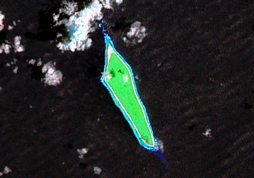
Flint Island - Landsat Image S-05-10_2000 (1" - 650 meters)
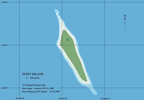
Flint Island - EVS Precision Map (1" - 650 meters)
"Flint Island is located about 740 kilometers (400 nautical miles) northwest of Tahiti, 190 km (100 nautical miles) south-southeast of Vostok Island, and 220 km (120 nautical miles) southwest of Caroline Island. The island is about 2.5 miles (4.0 km) long and 0.5 miles (0.80 km) wide at its widest point (4.0 by 0.8 km). It has a land area of 1 mi² (3 km ²) and rises to a height of 25 feet (8 m) above sea level. The island is surrounded by a narrow fringing reef and with no safe anchorage landing is difficult.
According to the U.S. Exploring Expedition (February 5, 1841), the island was thickly wooded, however the island is now mostly covered with planted coconut palms."
The above infornmation is taken from Wikipedia. The article contains a wealth of information about Flint Island. But my interest is different. My interest is about making a map of this island quickly, accurately and a quality presentation.
Here is the background. I will respect the privacy of the names of individuals contacting me and the publications they represent. I got an email today from a well-known individual representing a stellar publication gathering information on the Line Islands. I have done some mapping in this island group. I have not mapped Flint Island. I figured that I would map it and share my finished project with this individual. Certain they will be impressed by this effort, perhaps my maps might end up in this stellar publication's pages. Just maybe. Oh well, if nothing comes of this effort, I have made an interesting map and I like it. I hope all of you...
Enjoy!
No comments:
Post a Comment