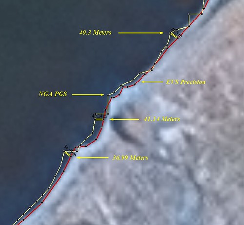
Comparison - NGA PGS to EVS Precision Vectors (1:6,250)
I know a good deal about global shoreline vector files. Specifically, global shoreline vector files that are free, available to the public and relatively easy to load and work with. This post's focus is a comparison of NGA's Prototype Global Shoreline (PGS) to Enhanced Vector Shoreline (EVS) Precision shorelines. This is not my first comparison of these two shorelines and it probably won't be my last, but here it goes.
NGA PGS vectors too often wobble off of the imaged coastline unnecessarily. The NGA PGS vectors were derived from Landsat ETM+ imagery, the same imagery I use to create EVS Precision shorelines. The above image is a small portion of Somalia's shoreline. The Landsat image is cloud free and the shoreline is easily distinguishable. NGA PGS used a complicated formula to determine the shoreline, but I don't see why their vectors misplot by as much as 41 meters from the imaged shoreline. No, this doesn't happen all of the time, but it happens enough, that if I am working at very large scales (1:50,000 to 1:12,500), I must redo the shoreline. Their shoreline is too far from image shoreline true.
I've been doing EVS Precision mapping for over 9 going on 10 years and my opinion concerning NGA PGS has not changed. Don't get me wrong, NGA PGS is the most detailed global shoreline available, one that I recommend heartily. However, for my work, creating detailed island maps, it isn't good enough.
Enjoy!
No comments:
Post a Comment