Just Thinking About It
Back in 1964, I was checking out reference books at a library. I happened upon a Geographical Dictionary. Leafing through that dictionary, I came upon an entry describing a small obscure island, Eiao. The entry stated that this island was 8 miles by 4 miles with elevations of 3,000 feet in the island's central plateau. At one time the island was inhabited. During the later part of the 19th century, the French used the island as a prison. Now the island was overrun by feral animals which were decimating what little native vegetation remained.
From that single incident came my fascination with islands. Like many people with a keen interest in islands, my reasons are many and most of these reasons having nothing to do with geography (stress, explorer, master-of-my-domain, etc.). What I discovered early on was the absence of readily-available maps. There were a few WW-II maps in out-of-print books, but no available collection of island maps.
Scripps Institute of Oceanography and Maps
That led to Scripps Institute of Oceanography and their excellent map collection. SIO does ocean-oriented research throughout the world. Consequently, they have a paper map collection of the world oceans and islands that rivals the best in the world. During the early 1980s, I spent many weekend hours pouring over this collection of maps and charts. The map librarian and I became acquainted and he allowed me access to their entire map and chart collection. It was both a joy and a curse, a sensory overload. I had access to every island paper map in the SIO collection and all I could think was, "So many islands, so little time."
My first idea was to amass my own collection of paper maps. This was the pre-digital and pre-affordable computer age. I would need to copy thousands of maps. No way! At 15 cents a copy, it just wasn't practical or affordable. I thought I could trace the shorelines of islands. Too many islands, too complicated, too time-consuming. Again, No way! So I stopped. That's right, stopped any island map aquisitions activities and went about my non-island map life.
Affordable Computers...
Which takes us to the late 1990s, the time of affordable computers, mega-storage, www and information everywhere. This was a time of digitizing paper map collections and one of the first was the Perry-Castenada Map Collection at the University of Texas. I'm not sure of the precise date that their collection went on-line, but many paper maps were freely available as raster images. Anyone could download them and amass their own digital map collection. During this time, I downloaded 100s of island maps. It was great fun, but I knew there was more. Raster maps were okay, but what about vector maps. They were considerably smaller in size and offered greater flexibility. In 2001, I went the way of the vectors.
The Way of The Vector
Not having money to spend on software, I became the master of the freeware and shareware world. I finally settled on Marplot for my mapping software and World Vector Shorelines from the NGDC Coastline Extractor. I remember downloading 100s of vector tiles onto 1.4MB floppies, taking them to my computer where I uploaded them into Marplot. It took about a month and I managed to load all of the world shorelines at 1:250,000 scale, 20,000+ placenames of major cities, 86,000+ placenames of islands and various other opportunistic layers of information.
Free Landsat ETM+. Global mapper and Google Earth
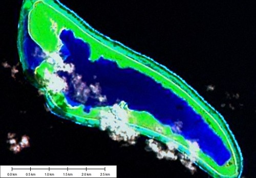
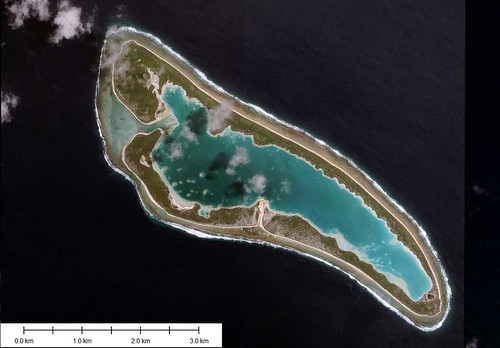
It was about three years ago that I discovered free Landsat ETM+. Turns out Bill Clinton, at the urging of Al Gore and others, made Landsat ETM+ georectified photo mosaics available for free. I spent that summer downloading all of the Landsat ETM+ images that covered oceanic islands of the world. It was at this time that I actually spent hard currency on my mapping passion and purchased Global Mapper. This software can load Landsat ETM+ in MrSid format effortlessly and has an above average digitizing toolkit. The final piece to my mapping project puzzle was Google Earth with DigitalGlobe imagery. As more and more hi-res imagery comes online, the quality of my work will be greatly enhanced.
What Now? Just Do It!
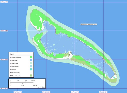
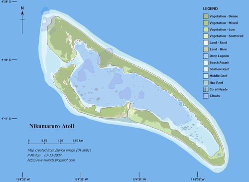
Since 2004, I have been making island maps. Since 2005, I have been posting my island maps on to my blogsite. Since 2007, I have been producing high-quality vector maps of islands. To date I have produced close to 200 maps covering easily 1,000+ individual islands. People ask why I give these maps away. They suggest that I need to charge for my work. I say to them, "We'll see." What I mean to say is, "No, I will not charge for my raster images of maps." If you want them, you can download them and use them. Just give credit where credit is due.
Today and In To The Future
I would love to guide an international team of neo-cartographers to complete a world shoreline map, including islands, using Landsat ETM+ imagery. Yes, I know all about the NGA Prototype Global Shoreline. Trust me, my world shoreline will be more accurate. I would love to guide that same team of international neo-cartographers in fashioning the next-generation Digtal Chart of the World. I would love to make all of this information available for free. In the spirit of Google, free.
So that is what I do. I continue to make high quality island maps and post them to my website. I continue to actively solicit serious offers toward sponsoring a world shoreline mapping project using an international team of neo-cartographers. This passion is what drives me forward and forward is always the best direction to be moving.Enjoy!
No comments:
Post a Comment