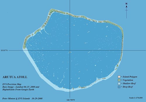
Arutua Atoll FP - EVS Precision Map (1:170,000) - Upper Image
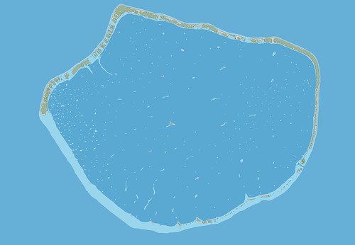
Arutua Atoll FP - EVS Precision map (1:75,000) - Lower Image
At first glance, except for a simple coordinate grid, use of a slightly different map scale and the addition of other necessary cartographic trappings, my original image of Arutua Atoll (upper) looks like the Arutua Atoll (lower). Although the images are both sized at 500 x 347 pixels, to fit into this web page, the two images are quite different. The upper image is JPG, whereas the lower image is PNG. I have been using PNG format images for my last few posts. Supposedly, they give one a better, sharper image at a much smaller size compared to JPG. Frankly, for what I am doing (posting an image of a vector map) the JPG format seemed to work fine. That is until I discovered my Global Mapper "Wow!".
I love my finished maps and enjoy sharing them with readers that appreciate my work. I believe most readers are often content to view an island image, read the brief article, ponder it and then go their merry way. As it should be. However, for the intrepid few that really want to check out the island map, that take the time to select the island image and view the original sized image in Flickr, have I got a treat for you!
If you select the lower Arutua Atoll image and follow it to Flickr, you will be able to view my original sized image of Arutua Atoll at a scale of 1:75,000. Global Mapper, my primary mapping software, allows me to capture a screen's contents to an image.

Global Mapper Image Capture
This is not a new discovery, as I have been using this option for years. But this morning I decided to changed the image size from a default of 1264 x 875 pixels to 2578 x 1750 pixels. This change transformed my 1:150,000 scaled island image into a 1:75,000 scaled island image. My original 1:150,000 scaled image will print on a standard 8.5" x 11" sheet of paper. To print my 1:75,000 scaled image would require a 21" x 14" paper. Within Flickr, the reader can view an image that more nearly displays the island at it's EVS precision viewing limits (between 1:75,000 to 1:50,000). Using Global Mapper to create my images, I am able to generate two additional files that allows one to view the island image with appropriate lat/lons (.pngw and .prj files).
My bottom line discovery - by varying Global Mapper's screen image capture size, I am able to quickly generate EVS precision island maps at meaningful viewing scales. And that's my 4:00 AM "Wow!"
Enjoy!
No comments:
Post a Comment