Shoreline Map Comparison - Yahoo, Google, MS and EVS Precison
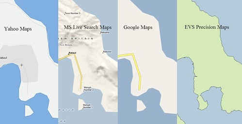
Whose shoreline maps are currently the most accurate? Is it Google Maps? They have loads of bucks and a keen desire to put the best product into their sites. They must have the most accurate shorelines. Right? Nope, not them. Yahoo! Maps, the current darling of the stock market and Google "wannabe", has the same clunky shoreline used by Google. MS Live Search Maps has the prettiest maps. Lots of shaded hills and valleys, but clunky shorelines. For sure, MicroSoft must have the most accurate shorelines. For sure, not.
Would you believe, EVS Precision Maps has the most accurate shorelines compared to the big three map moguls. EVS precision mapping is derived from Landsat ETM+. Typically, it provides accurate shoreline depiction at scales between 1:100,000 to 1:50,000.
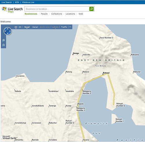
Rabul - MS Live Search Map
All map maker struggle with PPL (populated place) placement. The PPL data is available through NGA. I'm reasonably certain most of their data and locational information was derived from ONC (1:1,000,000) charts. Looking at the PPLs on the MS Live Search Map of the Rabul area, we see towns lined up in a grid. In the real world, this only happens in the midwest, not on New Britain Island in Papua New Guinea. One should replot these PPLs using Landsat ETM+ or hi-res imagery. The only thing certain about the above plots, is their locational uncertainty. But, back to shorelines.
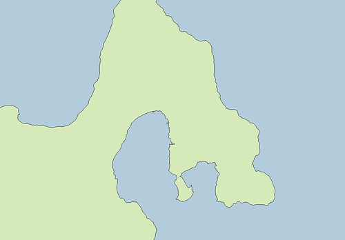
Rabul - EVS Precision Maps
EVS Precision Maps provide the most accurate shoreline maps of the four being compared. The big three use, what appears to be DCW's 1:1,000,000 shorelines. 1:1,000,000 has it's uses, but when one zooms to 1:63,500 (1" to 1-mi), a shoreline that approximates reality is expected. EVS Precision Maps show that expected shoreline. Google Maps, MS Live Search Maps and Yahoo Maps do not.
Enjoy!
P.S. - I am aware of NGA PGS vector files, 24 tiles covering much of the world. They were derived from Landsat ETM+. EVS Precision Maps and NGA PGS should parallel each other. They do not. NGA PGS vectors used a digitizing algorithm to automate their work. Peculiar stutters, uncalled for strings of vectors and angular shorelines are often the norm. Also, NGA requested that water inundated areas (swamps, marshes, tidal flats) be excluded. This caused a great many problems in shoreline mapping. Also, the slightest cloud cover often thwarted their automated digitizing efforts. EVS Precision Maps consistently improve upon NGA PGS.
No comments:
Post a Comment