View Larger Map
Zoom In to See Pukaruha and Reao Atolls
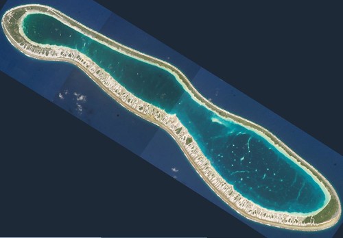
Reao Atoll FP - ISS004-E-12987, 12988, 12989 Images Modified (1:75,000)
For whatever reason Landsat ETM+ does not have a mosaic that covers Reao Atoll. Google Earth has Landsat imagery, but no imagery for this area at the NASA site where I download my Landsat ETM+'s. As I am making all of my maps without using DigitalGlobe imagery, because one day I might want to sell my shorelines, I must locate other imagery sources. The International Space Station (ISS) is a source of sometimes excellent imagery. And, in fact, ISS004 has 3 cloud-free, highly detailed images covering Reao Atoll, my current target project.
I downloaded, modified their sizes, constructed a "whole atoll" mosaic, rotated the image to align it with my base island shoreline vectors (NGA PGS vectors) and georectified this image using 7 GCPs.
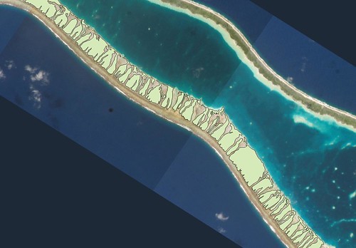
Reao Atoll FP - Other Precision Mapping on ISS Images - Finished Motus (1:40,000)
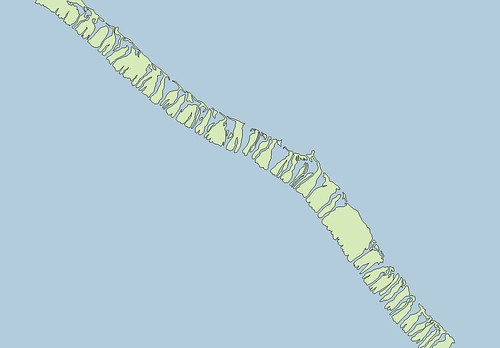
Reao Atoll FP - Other Precision Mapping - Finished Motus (1:40,000)
Once I had a georectified image, my digitizing could proceed. I decided to map motus first, thus the title of this post. Motu mapping is quick, repetitive and gives one a sense of completion. Each motu is actually a small island. Reao Atoll will ultimately be made up of a 100 or more islands. The two above images show the results of about 2-hours worth of digitizing. I always strive for EVS precision, Landsat ETM+ resolution or better. This imagery allows me to exceed EVS precision. For mapping quality purposes, I label it as Other precision and label it's Source attribute as ISS-Hi Res. I have completed 58 Other precision island polygons. Let's look at the challenges one encounters as they map motus.

Reao Atoll FP - Other Precision - Digitizing Motu (1:10,000)
First, I am working at 1:10,000 scale. At this scale, I am able to maintain sharp feature clarity. In addition, this resolution allows me to make consistent shoreline determinations that will work with the scale of my finished map, between 1:50,000 to 1:25,000. My mapped shorelines consist of actual or suspected (based on color) above-water features. Sounds easy enough to consistently identify, but it isn't. After mapping a few thousand motus, I have learned to make a color(s) to shoreline decision and rigourously adhere to that definition. In imagery, color is god.
In the Reao Atoll image, the motu shorelines are identified as a white sand color. Having studied enough hi-res 1-meter imagery of reefs and motus, I know that between motus are features called hoas. These serve as channels allowing water to flow in and out of the lagoon. Eventually, these hoas fill up with coral rubble and sand, vegetation takes root and motus join motus to form a continuous land ring around a lagoon. Given enough time, the lagoon quite often fills in and, sea level cooperating, a flat island forms where an atoll once stood. Using my white sand color as my motu shoreline, I began digitizing.
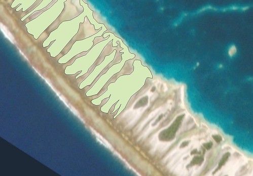
Reao Atoll FP - Other Precision Mapping - Finished Motu (1:10,000)
If I do a good job, my project consists of a series of motu shorelines. The digitizing is monotonous, eye-straining and lately, my feet hurt because my chair is uncomfortable. But the finished map is what I work for. I'll share it with you when I've finished. Until then...
Enjoy!
No comments:
Post a Comment