I was explaining my mapping work to a person I met at a party earlier today. This individual asked all of the right questions ( What do you do? Where do you get your images? How do you digitize the shorelines? What do you do with your finished maps?) Poor guy! I answered every question with a detailed, lengthy and somewhat technically boring response. After my fifth lengthy reply, he excused himself and joined another group.
As I reflect on my exchange with this curious person, I am amazed at the breadth of my knowledge and convinced that I can be very boring. I really do know quite abit about digitizing shorelines. After a few thousand kilometers of continental shorelines and 9,000 island shorelines, I am able to digitize a precise shoreline (within the limitations of Landsat ETM+'s 14.5-meter resolution).
Early on, I had professional cartographers tell me my maps would be useful at 1:125,000 to 1:63,500. I have learned that my island shoreline maps are useful at scales well-below these upper limits. I typically post completed maps at 1:25,000 scale. After adding layers of information, they work well for an individual attempting to determine a relatively coarse view of an island. Landsat is not DigitalGlobe's hi-res imagery, but it does a great job at giving one a highly resolved broad view of a geographical area.
New Britain PP - Digitizing from Landsat S-55-05_2000 (1:19960)
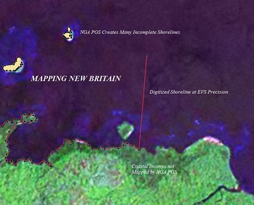
So, how is it that I do what I do? In digitizing, that is. The above image shows a typical stretch of large island shoreline. An attempt to generate vector shorelines from Landsat ETM+ was done a few years ago. This data, called NGA PGS, is fairly good at defining a shoreline, but coastal swamps are excluded causing some very strange looking maps of islands. If the island or shoreline contains water-innundated shoreline, NGA PGS does not map it. They could have, but someone, somewhere thought it would be good to exclude it. My shorelines include these water-innundated areas. The red line in the above image is my completed EVS precision shoreline. Except for the final vector which I purposely placed in the sea, the shoreline is much more accurately delineated than NGA PGS, WVS, DCW or any of the other available global shorelines. I am not saying EVS precision shorelines are global yet. I am an optimist. Someone, somewhere, sooner than later will fund my mapping efforts and the result will be a global shoreline at EVS precision.
Enjoy!

No comments:
Post a Comment