EPIP - Pacific Islands Overview
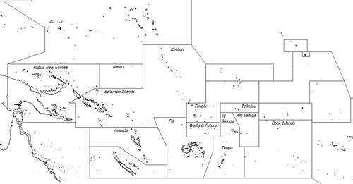
The 8,000 islands located in the following island groups: Papua New Guinea, Solomon Islands, Vanuatu, Fiji, Cook Islands, Western Samoa, Tonga and portions of Kiribati were mapped at EVS precision. Using Landsat ETM+ ortorectified image mosaics, which typically resolve to 14.5 meters per pixel as base imagery, Mr Minton spent in excess of 240-hours over 31-days digitizing, correcting and finalizing island shorelines throughout this region of the Pacific. Mr Minton used a variety of strategies to resolve cloud-obscured shorelines. Those that ultimately could not be resolved were mapped using World Vector shorelines. This impressive effort is being fine tuned using 1990 Landsat imagery, when available.
You heard it right! I spent the last month mapping thousands of islands at EVS precision. I did get paid to do it. Part of me wants to rest, as I sure deserve it. However, the island mapper in me demands that I resolve problem areas, primarily cloud-obscured areas, by correcting island shorelines using cloud-free imagery.
If you are interested in these shorelines, email me and let's talk.
Finally, I will finish mapping the balance of the Pacific islands at EVS precision. Stay tuned for updates on this effort.
Enjoy!

No comments:
Post a Comment