Vatican City - DigitalGlobe Image Mosaic from Google Earth (1-580000)
My evening began innocently enough. A friend wanted to know something about an island in the Northern Mariana Islands. My first search involved Google Earth. After a few hours devoted to looking at islands scattered about the Pacific Ocean , I began to wander, you know "Google Earth wandering". Before long I was following the southern coast of France and Italy. And before I knew it, I was looking at Vatican City. Follow the preceding link and you can read an article about Vatican City. What I want to discuss is inspiration and hi-res imagery in Google Earth.
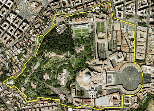
As I viewed Vatican City it appeared as a small island (44 hectares). The borders used in GE poorly track the city boundaries. I knew I could do better. First I needed to construct a DigitalGlobe image mosaic from which I could digitize a new border, a more accurate one. I could have drawn the polyline in GE, but what fun is that when you can spend a few hours constructing your very own image mosaic. I took a total of 30 screen shots at a scale of 1:250 from GE. Using ImageForge software I created a canvas 6000 x 4000 pixels to accommodate my finished mosaic. Using Irfanview software from which to select portions of images, I worked through 30 cut and pastes, ending up with the above image. My final image is 12.5 MBs and is 4980 x 3560 pixels in size. After georectifying, I zoomed about Vatican City to my heart's content. Maybe I'll try my own map of Vatican City later and maybe not.
It is just fun to construct one of these DigitalGlobe image mosaics using their hi-res imagery found in Google Earth. Take care and...
Enjoy!
No comments:
Post a Comment