View Larger Map

Bastoy Island - Landsat ETM+ Image N-32-55_2000 (1-20,000)

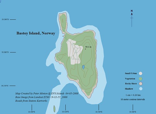
Bastoy Island - EVS Precision Map (1-20,000)
When I was a young man I learned a language that used to be widely practiced. Now it is an oddity employed by radio amateurs. Morse code was once the primary method of communication within many sectors of the world of the 1960's and 70's. I encountered it in the military. I still enjoy hearing the "dits" and "dahs".
This island is home for Norway's privledged prisoners. Apparently, Bastoy Island is a minimum security prison that is a choice location for all convicted Norwegian criminals. Not only prisoners visit this island, but radio amateurs as well.
Bastoy Island will be the location that LA4HNA and friends will transmit from between June 20-22, 2008. He will not transmit in CW (morse code), but will use RTTY and SSB. Oh, well, that's ok.
I like RSGBIOTA (Radio Society of Great Britain Islands On The Air). They encourage amateur radio transmissions from islands around the world - a real natural for me.
Someone that looked at LA1NIS's website visited EVS Islands, perhaps looking for a map of Bastoy Island. If they wanted one, now they have it. The map took about 2-hours to complete. The best resolution imagery is Landsat ETM+. However, Statens Kartverks has excellent, highly detailed mapping for all of Norway. I used their mapping to digitize the road network on the island.
. -. .--- --- -.--!
No comments:
Post a Comment