Nikumaroro Atoll - Marplot Map (1:30,000)
This is my third time posting this. I received an e-mail from a representative of TIGHAR, a group that has visited this atoll searching for clues to the whereabouts of Amelia Earhart. He asked that I post the following information to discourage visits to the island. The only way one is allowed to visit is with permission of Kiribatian authorities. Read on.
"The best landing place, marked by a white pyramidal concrete structure, is about 0.3 mile S of the village. A boat channel has been cut through the reef in a 054˚ direction and in line with the concrete beacon. Landing should be attempted just after HW when there is less surf than on a rising tide. With a SE wind, landing can be effected in the lee of the wreck at any stage of the tide."
(Sailing Directions Pub-126)
Comment from Pat Thrasher at TIGHAR: The beacon is long gone. It was cleaned off by a storm in 1990 or so. The wreck is gone except for the shell of the triple expansion steam engine. No lee.
BUT. It is completely, utterly ILLEGAL for anyone to land there at all. It is a protected area, bird sanctuary, and about to become a World Heritage Site. No fishing, no landing, no nothing, except as sanctioned by the government of the Republic of Kiribati. We have permission and will have a Customs officer with us. No equipment may be landed without strict adherence to environmental concerns about introduction of insects, bacteria, molds, etc.
Nikumaroro is a sensitive archeological and cultural site. I hope you will discourage landings rather than promoting them with information about when and where to make them!
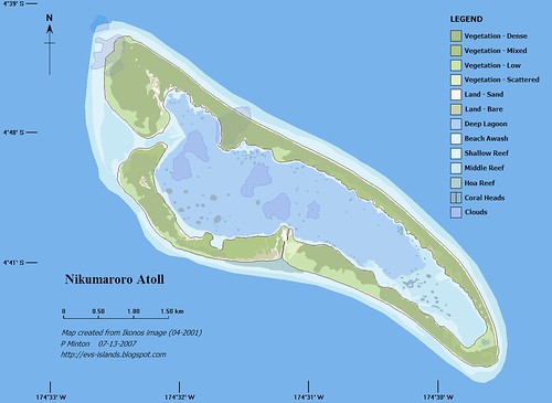
Nikumaroro Atoll KR
Nikumaroro Atoll (Gardner Island) (4˚40'S., 174˚31'W.) is a wooded, wedge-shaped atoll lying about 137 miles W of Orona Atoll (Hull Island). The atoll is surrounded by a fringing reef, which dries at LW, extending about 0.2 mile offshore. The NW and SE extremities of the reef appears to be extending. Depths off the atoll, which is steep-to except at its NW and SE extremities, average 366m, 0.3 mile from the reef. Nikumaroro Atoll (Gardner Island) encloses a lagoon into which there is no navigable passage. With the exception of two breaks, a large one on the W side and a narrow one on the S side, the land rim of the atoll entirely surrounds the lagoon.
The lagoon is encumbered with coral heads, but seaplanes have landed successfully.
A conspicuous stranded wreck lies close W of the N extremity of the atoll. The wreck was reportedly breaking up.
Tides—Currents.—Off the atoll the set is W, and varies in direction and strength with the prevailing wind. Close inshore, the current follows the trend of the land to the W. There is a deserted village on the W side of the atoll, about 1 mile S of the N extremity, off which anchorage may be obtained by small vessels, very close inshore. Two small beacons N of the village indicate the approach.
Directions.—The best landing place, marked by a white pyramidal concrete structure, is about 0.3 mile S of the village. A boat channel has been cut through the reef in a 054˚ direction and in line with the concrete beacon. Landing should be attempted just after HW when there is less surf than on a rising tide. With a SE wind, landing can be effected in the lee of the wreck at any stage of the tide. The reef is extremely slippery and wide, and the landing is not recommended if any equipment is to be landed or brought off. (SD Pub-126)
This is a redo of a previous post dated 2/25/2006. I wanted to bring in my current colors and include the standard images and maps (1:200,000, 1:100,000, 1:50,000 and 1:25,000). In addition, I wanted to show the Ikonos image that was used to help in digitizing the vectors that makeup this map.
If you have difficulties reading the Flash presentation, go directly to my Flickr account and check out the set of images with the same name as the title of this post.
Enjoy!
No comments:
Post a Comment