The Effect of Blends and Backgrounds on LIIMs
I most often digitize from LIIMs using Global Mappers's Blend Mode called No Blend (Slide 1). No Blend shows the various land and water features as Landsat ETM+ mosaics intended them to look - somewhat natural. For most projects, this image works fine. However, atolls present some unique challenges - What is above water and what is below? What is shore vegetation and what is bare earth that looks like shore vegetation? Where does the land end and the reef begin? Like I said, unique challenges.
When I encounter these challenges, I use a couple of different options - 1) changing the background color to either Yellow (R-157,G-191,B-202), Pink (R-255,G-128,B-192), Light Pink (R-255,G-193,B-224) and Blue (R-157,G-191,B-202) and using two new Blend Modes - Difference and Color Burn. Let's talk about Difference first.
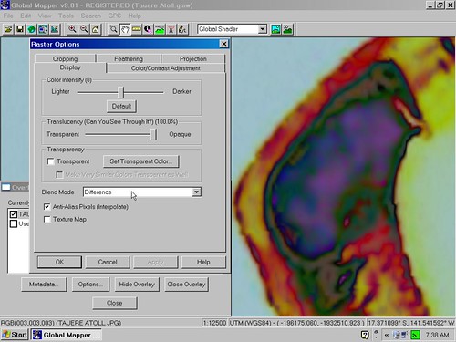
Tauere Atoll - Blend Mode Difference and Blue Background
Difference creates a soft looking false color image that makes certain atoll features stand out, for example the sand. It is also a great way to distinguish underwater features. I always switch between No Blend and Difference to visually confirm my work.
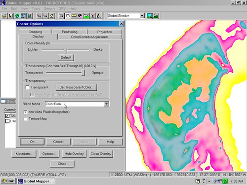
Tauere Atoll - Blend Mode Color Burn and Blue Background
Color Burn creates a sharp separation using false colors. The blue background and Color Burn allows for some potentially very precise digitizing of various island features. Using the other background colors, other than blue, gives a washed out effect. Not very handy for digitizing work.
My biggest challenge when working on an island mapping project is determining the shoreline - where the water meets the mostly dry land. Using the Global Mapper's Blend Mode and changing background colors is a great way to meet this challenge.
Enjoy!
No comments:
Post a Comment