
Nisida Ioura - LIIM From N-34-35_2000 (1:65,000)
So you've always wanted to hand-digitize an island shoreline. Your GIS friends tell you "No way! It takes way too long. And it's not as accurate as some of these slick black-box vectorizing software packages." You ignore them. Good for you!
First get you a good software package to digitize from. You all know where I stand - Global Mapper. You can always download and try their software for free. Just select my Global Mapper sidebar link and follow the instructions. Once you've got the mapping software loaded, it is time to get your base imagery. You can either download it from the NASA site or get in touch with me and I'll hook you up with imagery for your island.
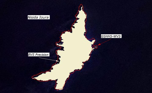
Nisida Ioura - EVS Precision and GSHHS WVS (1:65,000)
Load the imagery into GM, zoom into a section of the shoreline where you will begin digitizing at a scale of 1:12,500, switch on Anti-Alias option in the Control Panel for your base image, select the digitizing tool, select the "Draw a Line" option and start digitizing. I like digitizing to music. This morning it was "The Planets" by Gustav Holst. I traced the above island's shoreline, listened to music and sipped a cup of coffee. I started at 5:50AM and finished Nisida Ioura's shoreline at 6:05AM - 15-minutes to digitize a perimeter of 30-kilometers - 2-kilometers per minute.
I always experience a satisfying sense of accomplishment when I complete an island's shoreline at EVS precision. I know that my island shorelines are as accurate as one can get using the tools I use. I have done enough comparisons to know that my shorelines can be used to create useful maps suitable for a wide range of activities.
If you want to make your own maps, just do it. Stop making excuses. Stop letting others tell you what you can or can't do. Go ahead and make your map. If your first one looks crappy, I promise your next one will look less crappy. And after a few years of making your own maps - you'll be able to say "Now, that's a nice map!"
Enjoy!
No comments:
Post a Comment